You are here: Home > Network List > G - GEOSCOPE Stations List
> Station INU Inuyama, Japan > Earthquake Result Viewer
INU Inuyama, Japan - Earthquake Result Viewer
| Earthquake location: |
Banda Sea |
| Earthquake latitude/longitude: |
-6.7/129.9 |
| Earthquake time(UTC): |
2018/03/25 (084) 20:14:47 GMT |
| Earthquake Depth: |
172 km |
| Earthquake Magnitude: |
6.4 Mww |
| Earthquake Catalog/Contributor: |
NEIC PDE/us |
|
| Network: |
G GEOSCOPE |
| Station: |
INU Inuyama, Japan |
| Lat/Lon: |
35.35 N/137.03 E |
| Elevation: |
132 m |
|
| Distance: |
42.3 deg |
| Az: |
8.708 deg |
| Baz: |
190.601 deg |
| Ray Param: |
0.07260117 |
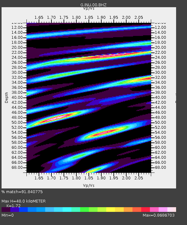
| Estimated Moho Depth: |
48.0 km |
| Estimated Crust Vp/Vs: |
1.72 |
| Assumed Crust Vp: |
6.461 km/s |
| Estimated Crust Vs: |
3.757 km/s |
| Estimated Crust Poisson's Ratio: |
0.24 |
|
| Radial Match: |
91.840775 % |
| Radial Bump: |
400 |
| Transverse Match: |
74.81671 % |
| Transverse Bump: |
400 |
| SOD ConfigId: |
2615551 |
| Insert Time: |
2018-04-08 20:15:41.904 +0000 |
| GWidth: |
2.5 |
| Max Bumps: |
400 |
| Tol: |
0.001 |
|
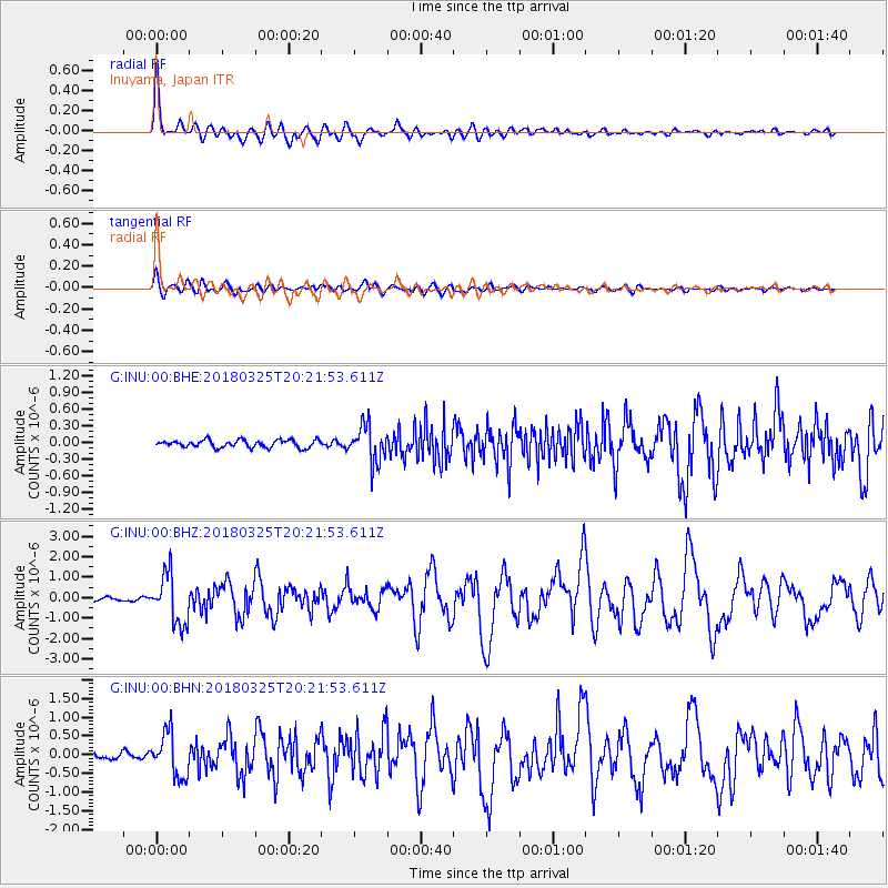
Signal To Noise
| Channel | StoN | STA | LTA |
| G:INU:00:BHZ:20180325T20:21:53.611Z | 12.683582 | 1.2005843E-6 | 9.4656556E-8 |
| G:INU:00:BHN:20180325T20:21:53.611Z | 6.020215 | 5.8816374E-7 | 9.769813E-8 |
| G:INU:00:BHE:20180325T20:21:53.611Z | 4.939439 | 3.2936208E-7 | 6.668006E-8 |
| Arrivals |
| Ps | 5.7 SECOND |
| PpPs | 19 SECOND |
| PsPs/PpSs | 25 SECOND |


