You are here: Home > Network List > UW - Pacific Northwest Regional Seismic Network Stations List
> Station IRON Crane, OR, USA > Earthquake Result Viewer
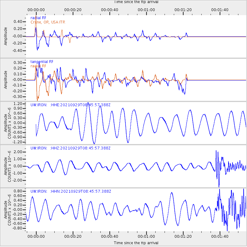
IRON Crane, OR, USA - Earthquake Result Viewer
*The percent match for this event was below the threshold and hence no stack was calculated.
| Earthquake location: |
East Of Kuril Islands |
| Earthquake latitude/longitude: |
45.8/153.5 |
| Earthquake time(UTC): |
2021/09/29 (272) 08:37:05 GMT |
| Earthquake Depth: |
401 km |
| Earthquake Magnitude: |
6.5 Mi |
| Earthquake Catalog/Contributor: |
NEIC PDE/pt |
|
| Network: |
UW Pacific Northwest Regional Seismic Network |
| Station: |
IRON Crane, OR, USA |
| Lat/Lon: |
43.36 N/118.47 W |
| Elevation: |
1226 m |
|
| Distance: |
59.6 deg |
| Az: |
57.711 deg |
| Baz: |
305.824 deg |
| Ray Param: |
$rayparam |
*The percent match for this event was below the threshold and hence was not used in the summary stack. |
|
| Radial Match: |
68.863686 % |
| Radial Bump: |
301 |
| Transverse Match: |
71.16171 % |
| Transverse Bump: |
355 |
| SOD ConfigId: |
25131211 |
| Insert Time: |
2021-10-13 08:56:16.225 +0000 |
| GWidth: |
2.5 |
| Max Bumps: |
400 |
| Tol: |
0.001 |
|
Signal To Noise
| Channel | StoN | STA | LTA |
| UW:IRON: :HHZ:20210929T08:45:57.388Z | 0.7844106 | 3.8594425E-7 | 4.920181E-7 |
| UW:IRON: :HHN:20210929T08:45:57.388Z | 0.96720207 | 3.0990893E-7 | 3.20418E-7 |
| UW:IRON: :HHE:20210929T08:45:57.388Z | 2.0394692 | 8.4935203E-7 | 4.1645737E-7 |
| Arrivals |
| Ps | |
| PpPs | |
| PsPs/PpSs | |


