You are here: Home > Network List > AV - Alaska Volcano Observatory Stations List
> Station AMKA Regional Station, Amchitka Island, Alaska > Earthquake Result Viewer
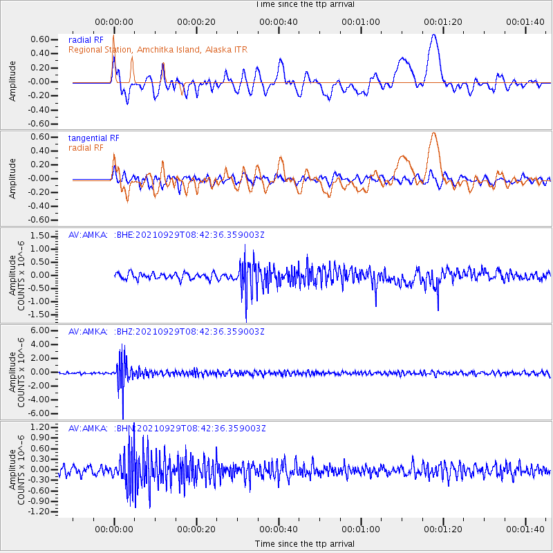
AMKA Regional Station, Amchitka Island, Alaska - Earthquake Result Viewer
*The percent match for this event was below the threshold and hence no stack was calculated.
| Earthquake location: |
Sea Of Japan |
| Earthquake latitude/longitude: |
38.9/135.5 |
| Earthquake time(UTC): |
2021/09/29 (272) 08:37:05 GMT |
| Earthquake Depth: |
368 km |
| Earthquake Magnitude: |
6.1 Mww |
| Earthquake Catalog/Contributor: |
NEIC PDE/us |
|
| Network: |
AV Alaska Volcano Observatory |
| Station: |
AMKA Regional Station, Amchitka Island, Alaska |
| Lat/Lon: |
51.38 N/179.30 E |
| Elevation: |
116 m |
|
| Distance: |
32.9 deg |
| Az: |
53.117 deg |
| Baz: |
265.029 deg |
| Ray Param: |
$rayparam |
*The percent match for this event was below the threshold and hence was not used in the summary stack. |
|
| Radial Match: |
47.61759 % |
| Radial Bump: |
400 |
| Transverse Match: |
54.09267 % |
| Transverse Bump: |
400 |
| SOD ConfigId: |
25131211 |
| Insert Time: |
2021-10-13 09:03:55.102 +0000 |
| GWidth: |
2.5 |
| Max Bumps: |
400 |
| Tol: |
0.001 |
|
Signal To Noise
| Channel | StoN | STA | LTA |
| AV:AMKA: :BHZ:20210929T08:42:36.359003Z | 17.566912 | 1.8981251E-6 | 1.0805115E-7 |
| AV:AMKA: :BHN:20210929T08:42:36.359003Z | 5.1904964 | 4.859522E-7 | 9.362346E-8 |
| AV:AMKA: :BHE:20210929T08:42:36.359003Z | 5.3255672 | 6.0570665E-7 | 1.1373561E-7 |
| Arrivals |
| Ps | |
| PpPs | |
| PsPs/PpSs | |


