You are here: Home > Network List > AK - Alaska Regional Network Stations List
> Station BMR Bremner River > Earthquake Result Viewer
BMR Bremner River - Earthquake Result Viewer
| Earthquake location: |
Kermadec Islands Region |
| Earthquake latitude/longitude: |
-31.8/-179.3 |
| Earthquake time(UTC): |
2006/05/16 (136) 10:39:23 GMT |
| Earthquake Depth: |
152 km |
| Earthquake Magnitude: |
6.8 MB, 7.4 MW, 7.4 MW |
| Earthquake Catalog/Contributor: |
WHDF/NEIC |
|
| Network: |
AK Alaska Regional Network |
| Station: |
BMR Bremner River |
| Lat/Lon: |
60.97 N/144.60 W |
| Elevation: |
842 m |
|
| Distance: |
96.7 deg |
| Az: |
16.239 deg |
| Baz: |
209.226 deg |
| Ray Param: |
0.04031857 |
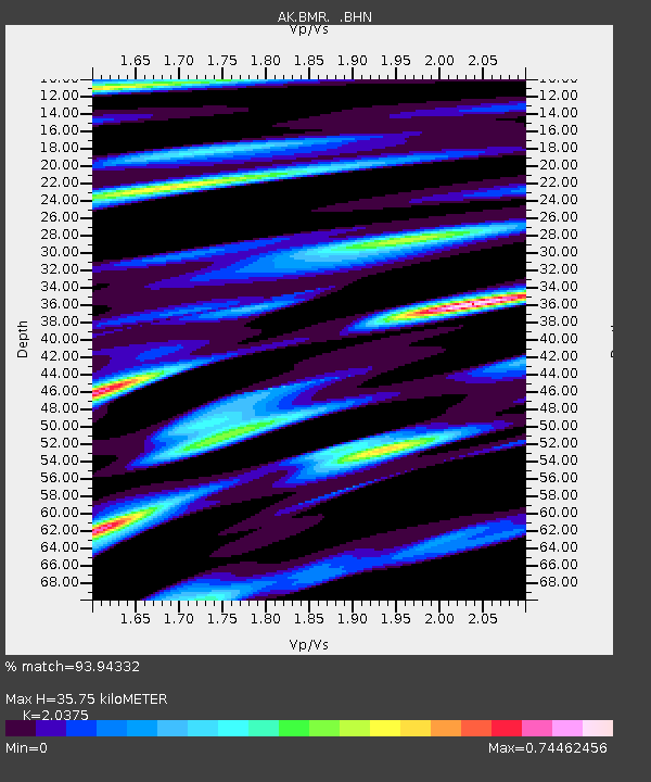
| Estimated Moho Depth: |
35.75 km |
| Estimated Crust Vp/Vs: |
2.04 |
| Assumed Crust Vp: |
6.566 km/s |
| Estimated Crust Vs: |
3.223 km/s |
| Estimated Crust Poisson's Ratio: |
0.34 |
|
| Radial Match: |
93.94332 % |
| Radial Bump: |
400 |
| Transverse Match: |
89.36659 % |
| Transverse Bump: |
400 |
| SOD ConfigId: |
2669 |
| Insert Time: |
2010-03-09 13:10:20.814 +0000 |
| GWidth: |
2.5 |
| Max Bumps: |
400 |
| Tol: |
0.001 |
|

Signal To Noise
| Channel | StoN | STA | LTA |
| AK:BMR: :BHN:20060516T10:52:04.800022Z | 3.2372308 | 3.055206E-7 | 9.4377135E-8 |
| AK:BMR: :BHE:20060516T10:52:04.800022Z | 3.286589 | 3.6244614E-7 | 1.1028035E-7 |
| AK:BMR: :BHZ:20060516T10:52:04.800022Z | 11.682879 | 1.3796437E-6 | 1.1809106E-7 |
| Arrivals |
| Ps | 5.7 SECOND |
| PpPs | 16 SECOND |
| PsPs/PpSs | 22 SECOND |


