You are here: Home > Network List > IU - Global Seismograph Network (GSN - IRIS/USGS) Stations List
> Station JOHN Johnston Island, USA > Earthquake Result Viewer
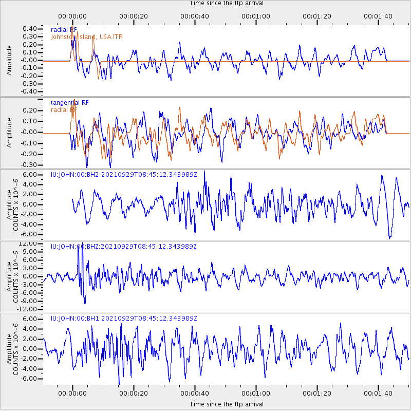
JOHN Johnston Island, USA - Earthquake Result Viewer
*The percent match for this event was below the threshold and hence no stack was calculated.
| Earthquake location: |
Sea Of Japan |
| Earthquake latitude/longitude: |
38.9/135.5 |
| Earthquake time(UTC): |
2021/09/29 (272) 08:37:05 GMT |
| Earthquake Depth: |
368 km |
| Earthquake Magnitude: |
6.1 Mww |
| Earthquake Catalog/Contributor: |
NEIC PDE/us |
|
| Network: |
IU Global Seismograph Network (GSN - IRIS/USGS) |
| Station: |
JOHN Johnston Island, USA |
| Lat/Lon: |
16.73 N/169.53 W |
| Elevation: |
2.0 m |
|
| Distance: |
52.6 deg |
| Az: |
98.698 deg |
| Baz: |
306.361 deg |
| Ray Param: |
$rayparam |
*The percent match for this event was below the threshold and hence was not used in the summary stack. |
|
| Radial Match: |
60.185585 % |
| Radial Bump: |
400 |
| Transverse Match: |
49.50055 % |
| Transverse Bump: |
392 |
| SOD ConfigId: |
25131211 |
| Insert Time: |
2021-10-13 09:15:44.245 +0000 |
| GWidth: |
2.5 |
| Max Bumps: |
400 |
| Tol: |
0.001 |
|
Signal To Noise
| Channel | StoN | STA | LTA |
| IU:JOHN:00:BHZ:20210929T08:45:12.343989Z | 2.897376 | 4.940762E-6 | 1.7052539E-6 |
| IU:JOHN:00:BH1:20210929T08:45:12.343989Z | 1.0629721 | 2.2044674E-6 | 2.0738712E-6 |
| IU:JOHN:00:BH2:20210929T08:45:12.343989Z | 1.0127113 | 1.6428806E-6 | 1.6222596E-6 |
| Arrivals |
| Ps | |
| PpPs | |
| PsPs/PpSs | |


