You are here: Home > Network List > US - United States National Seismic Network Stations List
> Station LKWY Lake (Yellowstone--Lake), Wyoming, USA > Earthquake Result Viewer
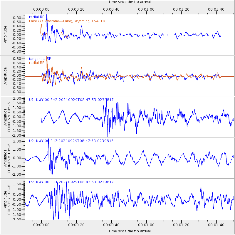
LKWY Lake (Yellowstone--Lake), Wyoming, USA - Earthquake Result Viewer
*The percent match for this event was below the threshold and hence no stack was calculated.
| Earthquake location: |
Sea Of Japan |
| Earthquake latitude/longitude: |
38.9/135.5 |
| Earthquake time(UTC): |
2021/09/29 (272) 08:37:05 GMT |
| Earthquake Depth: |
368 km |
| Earthquake Magnitude: |
6.1 Mww |
| Earthquake Catalog/Contributor: |
NEIC PDE/us |
|
| Network: |
US United States National Seismic Network |
| Station: |
LKWY Lake (Yellowstone--Lake), Wyoming, USA |
| Lat/Lon: |
44.57 N/110.40 W |
| Elevation: |
2424 m |
|
| Distance: |
77.9 deg |
| Az: |
41.839 deg |
| Baz: |
313.244 deg |
| Ray Param: |
$rayparam |
*The percent match for this event was below the threshold and hence was not used in the summary stack. |
|
| Radial Match: |
70.74887 % |
| Radial Bump: |
400 |
| Transverse Match: |
66.53915 % |
| Transverse Bump: |
400 |
| SOD ConfigId: |
25131211 |
| Insert Time: |
2021-10-13 09:25:46.825 +0000 |
| GWidth: |
2.5 |
| Max Bumps: |
400 |
| Tol: |
0.001 |
|
Signal To Noise
| Channel | StoN | STA | LTA |
| US:LKWY:00:BHZ:20210929T08:47:53.023981Z | 6.5443554 | 7.0347824E-7 | 1.0749389E-7 |
| US:LKWY:00:BH1:20210929T08:47:53.023981Z | 1.0649512 | 3.5518417E-7 | 3.3352154E-7 |
| US:LKWY:00:BH2:20210929T08:47:53.023981Z | 0.5675201 | 2.2011973E-7 | 3.8786246E-7 |
| Arrivals |
| Ps | |
| PpPs | |
| PsPs/PpSs | |


