You are here: Home > Network List > UW - Pacific Northwest Regional Seismic Network Stations List
> Station IRON Crane, OR, USA > Earthquake Result Viewer
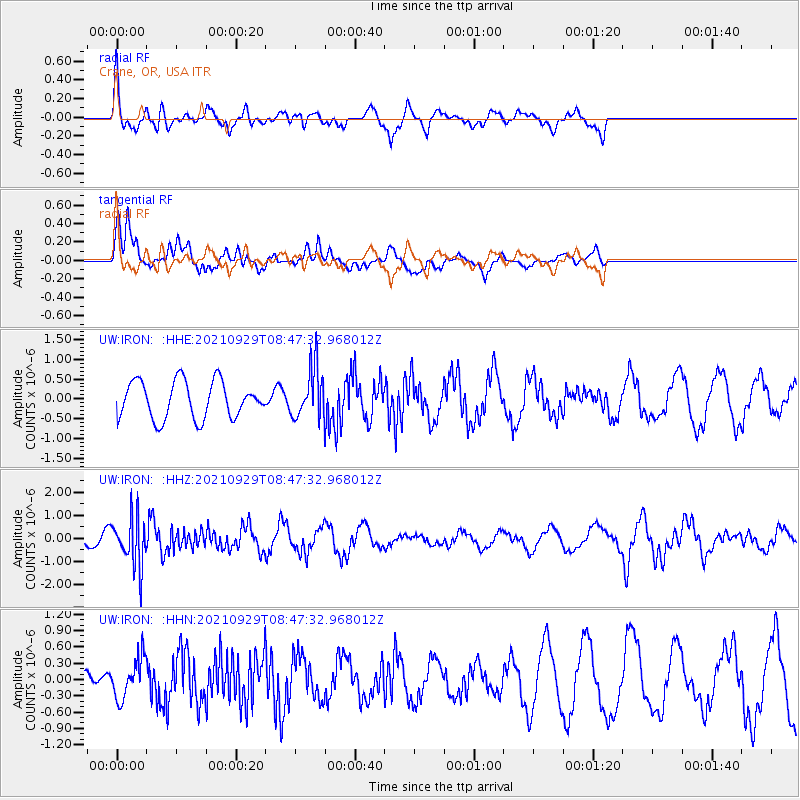
IRON Crane, OR, USA - Earthquake Result Viewer
*The percent match for this event was below the threshold and hence no stack was calculated.
| Earthquake location: |
Sea Of Japan |
| Earthquake latitude/longitude: |
38.9/135.5 |
| Earthquake time(UTC): |
2021/09/29 (272) 08:37:05 GMT |
| Earthquake Depth: |
368 km |
| Earthquake Magnitude: |
6.1 Mww |
| Earthquake Catalog/Contributor: |
NEIC PDE/us |
|
| Network: |
UW Pacific Northwest Regional Seismic Network |
| Station: |
IRON Crane, OR, USA |
| Lat/Lon: |
43.36 N/118.47 W |
| Elevation: |
1226 m |
|
| Distance: |
74.3 deg |
| Az: |
46.715 deg |
| Baz: |
308.823 deg |
| Ray Param: |
$rayparam |
*The percent match for this event was below the threshold and hence was not used in the summary stack. |
|
| Radial Match: |
61.38786 % |
| Radial Bump: |
400 |
| Transverse Match: |
73.40412 % |
| Transverse Bump: |
400 |
| SOD ConfigId: |
25131211 |
| Insert Time: |
2021-10-13 09:27:08.902 +0000 |
| GWidth: |
2.5 |
| Max Bumps: |
400 |
| Tol: |
0.001 |
|
Signal To Noise
| Channel | StoN | STA | LTA |
| UW:IRON: :HHZ:20210929T08:47:32.968012Z | 3.256502 | 1.0628906E-6 | 3.263903E-7 |
| UW:IRON: :HHN:20210929T08:47:32.968012Z | 1.0203698 | 3.654523E-7 | 3.5815674E-7 |
| UW:IRON: :HHE:20210929T08:47:32.968012Z | 1.3402997 | 6.277989E-7 | 4.6840185E-7 |
| Arrivals |
| Ps | |
| PpPs | |
| PsPs/PpSs | |


