You are here: Home > Network List > UW - Pacific Northwest Regional Seismic Network Stations List
> Station PASS Maple Falls, WA, USA > Earthquake Result Viewer
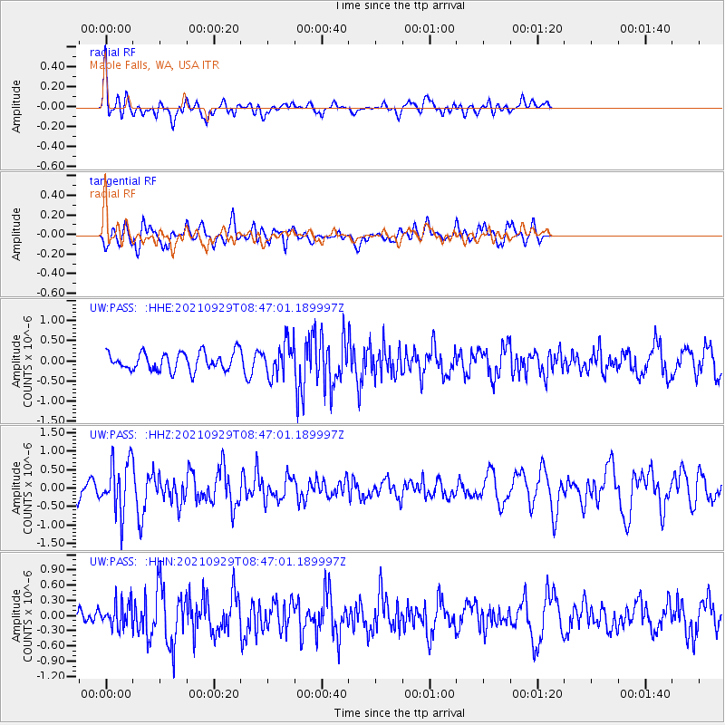
PASS Maple Falls, WA, USA - Earthquake Result Viewer
*The percent match for this event was below the threshold and hence no stack was calculated.
| Earthquake location: |
Sea Of Japan |
| Earthquake latitude/longitude: |
38.9/135.5 |
| Earthquake time(UTC): |
2021/09/29 (272) 08:37:05 GMT |
| Earthquake Depth: |
368 km |
| Earthquake Magnitude: |
6.1 Mww |
| Earthquake Catalog/Contributor: |
NEIC PDE/us |
|
| Network: |
UW Pacific Northwest Regional Seismic Network |
| Station: |
PASS Maple Falls, WA, USA |
| Lat/Lon: |
49.00 N/122.09 W |
| Elevation: |
174 m |
|
| Distance: |
68.9 deg |
| Az: |
43.565 deg |
| Baz: |
305.229 deg |
| Ray Param: |
$rayparam |
*The percent match for this event was below the threshold and hence was not used in the summary stack. |
|
| Radial Match: |
48.494072 % |
| Radial Bump: |
400 |
| Transverse Match: |
62.422096 % |
| Transverse Bump: |
400 |
| SOD ConfigId: |
25131211 |
| Insert Time: |
2021-10-13 09:27:39.932 +0000 |
| GWidth: |
2.5 |
| Max Bumps: |
400 |
| Tol: |
0.001 |
|
Signal To Noise
| Channel | StoN | STA | LTA |
| UW:PASS: :HHZ:20210929T08:47:01.189997Z | 2.7265837 | 7.0479905E-7 | 2.584916E-7 |
| UW:PASS: :HHN:20210929T08:47:01.189997Z | 0.8796329 | 2.4399606E-7 | 2.7738398E-7 |
| UW:PASS: :HHE:20210929T08:47:01.189997Z | 1.8360454 | 4.061451E-7 | 2.2120646E-7 |
| Arrivals |
| Ps | |
| PpPs | |
| PsPs/PpSs | |


