You are here: Home > Network List > IU - Global Seismograph Network (GSN - IRIS/USGS) Stations List
> Station JOHN Johnston Island, USA > Earthquake Result Viewer
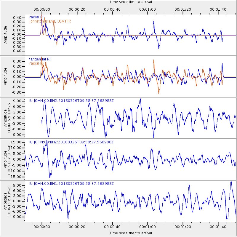
JOHN Johnston Island, USA - Earthquake Result Viewer
*The percent match for this event was below the threshold and hence no stack was calculated.
| Earthquake location: |
New Britain Region, P.N.G. |
| Earthquake latitude/longitude: |
-5.5/151.4 |
| Earthquake time(UTC): |
2018/03/26 (085) 09:51:00 GMT |
| Earthquake Depth: |
40 km |
| Earthquake Magnitude: |
6.6 mww |
| Earthquake Catalog/Contributor: |
NEIC PDE/us |
|
| Network: |
IU Global Seismograph Network (GSN - IRIS/USGS) |
| Station: |
JOHN Johnston Island, USA |
| Lat/Lon: |
16.73 N/169.53 W |
| Elevation: |
2.0 m |
|
| Distance: |
44.5 deg |
| Az: |
59.541 deg |
| Baz: |
243.582 deg |
| Ray Param: |
$rayparam |
*The percent match for this event was below the threshold and hence was not used in the summary stack. |
|
| Radial Match: |
64.77557 % |
| Radial Bump: |
400 |
| Transverse Match: |
45.186733 % |
| Transverse Bump: |
400 |
| SOD ConfigId: |
2615551 |
| Insert Time: |
2018-04-09 09:53:16.797 +0000 |
| GWidth: |
2.5 |
| Max Bumps: |
400 |
| Tol: |
0.001 |
|
Signal To Noise
| Channel | StoN | STA | LTA |
| IU:JOHN:00:BHZ:20180326T09:58:37.568988Z | 2.6823776 | 9.607512E-6 | 3.581715E-6 |
| IU:JOHN:00:BH1:20180326T09:58:37.568988Z | 1.1603159 | 3.6713525E-6 | 3.1640975E-6 |
| IU:JOHN:00:BH2:20180326T09:58:37.568988Z | 1.3471987 | 5.3007125E-6 | 3.934618E-6 |
| Arrivals |
| Ps | |
| PpPs | |
| PsPs/PpSs | |


