You are here: Home > Network List > UW - Pacific Northwest Regional Seismic Network Stations List
> Station UMAT Pilot Rock, OR, USA > Earthquake Result Viewer
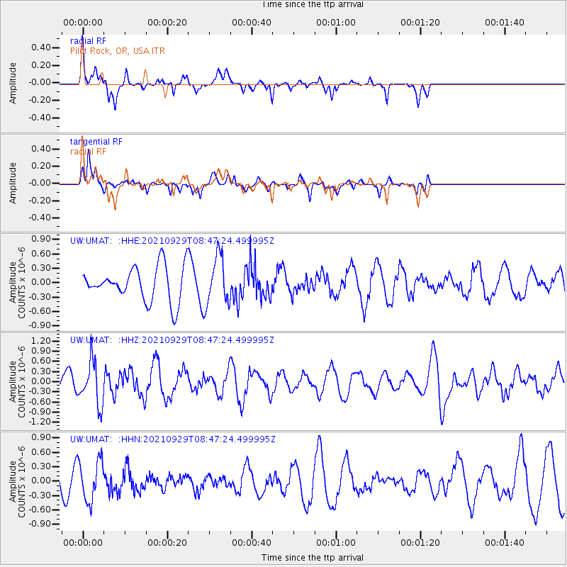
UMAT Pilot Rock, OR, USA - Earthquake Result Viewer
*The percent match for this event was below the threshold and hence no stack was calculated.
| Earthquake location: |
Sea Of Japan |
| Earthquake latitude/longitude: |
38.9/135.5 |
| Earthquake time(UTC): |
2021/09/29 (272) 08:37:05 GMT |
| Earthquake Depth: |
368 km |
| Earthquake Magnitude: |
6.1 Mww |
| Earthquake Catalog/Contributor: |
NEIC PDE/us |
|
| Network: |
UW Pacific Northwest Regional Seismic Network |
| Station: |
UMAT Pilot Rock, OR, USA |
| Lat/Lon: |
45.29 N/118.96 W |
| Elevation: |
1318 m |
|
| Distance: |
72.9 deg |
| Az: |
45.364 deg |
| Baz: |
308.104 deg |
| Ray Param: |
$rayparam |
*The percent match for this event was below the threshold and hence was not used in the summary stack. |
|
| Radial Match: |
63.253498 % |
| Radial Bump: |
322 |
| Transverse Match: |
67.22654 % |
| Transverse Bump: |
350 |
| SOD ConfigId: |
25131211 |
| Insert Time: |
2021-10-13 09:28:05.553 +0000 |
| GWidth: |
2.5 |
| Max Bumps: |
400 |
| Tol: |
0.001 |
|
Signal To Noise
| Channel | StoN | STA | LTA |
| UW:UMAT: :HHZ:20210929T08:47:24.499995Z | 1.7916445 | 6.5629325E-7 | 3.6630775E-7 |
| UW:UMAT: :HHN:20210929T08:47:24.499995Z | 2.455997 | 4.2769597E-7 | 1.7414354E-7 |
| UW:UMAT: :HHE:20210929T08:47:24.499995Z | 1.4066575 | 5.032304E-7 | 3.577491E-7 |
| Arrivals |
| Ps | |
| PpPs | |
| PsPs/PpSs | |


