You are here: Home > Network List > KR - Kyrgyz Digital Network Stations List
> Station SALK Salom-Alik, Kyrgyzstan > Earthquake Result Viewer
SALK Salom-Alik, Kyrgyzstan - Earthquake Result Viewer
| Earthquake location: |
Solomon Islands |
| Earthquake latitude/longitude: |
-7.1/154.8 |
| Earthquake time(UTC): |
2021/10/02 (275) 02:17:13 GMT |
| Earthquake Depth: |
10 km |
| Earthquake Magnitude: |
5.4 Mww |
| Earthquake Catalog/Contributor: |
NEIC PDE/us |
|
| Network: |
KR Kyrgyz Digital Network |
| Station: |
SALK Salom-Alik, Kyrgyzstan |
| Lat/Lon: |
40.88 N/73.82 E |
| Elevation: |
1672 m |
|
| Distance: |
87.8 deg |
| Az: |
311.464 deg |
| Baz: |
101.246 deg |
| Ray Param: |
0.043028392 |
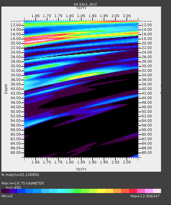
| Estimated Moho Depth: |
18.75 km |
| Estimated Crust Vp/Vs: |
1.65 |
| Assumed Crust Vp: |
6.306 km/s |
| Estimated Crust Vs: |
3.81 km/s |
| Estimated Crust Poisson's Ratio: |
0.21 |
|
| Radial Match: |
82.108955 % |
| Radial Bump: |
400 |
| Transverse Match: |
81.0017 % |
| Transverse Bump: |
370 |
| SOD ConfigId: |
25131211 |
| Insert Time: |
2021-10-16 02:25:29.550 +0000 |
| GWidth: |
2.5 |
| Max Bumps: |
400 |
| Tol: |
0.001 |
|

Signal To Noise
| Channel | StoN | STA | LTA |
| KR:SALK: :BHZ:20211002T02:29:31.040002Z | 2.5062785 | 1.8934796E-7 | 7.5549444E-8 |
| KR:SALK: :BHN:20211002T02:29:31.040002Z | 1.0257679 | 2.3998967E-7 | 2.33961E-7 |
| KR:SALK: :BHE:20211002T02:29:31.040002Z | 1.5027161 | 1.6018561E-6 | 1.065974E-6 |
| Arrivals |
| Ps | 2.0 SECOND |
| PpPs | 7.7 SECOND |
| PsPs/PpSs | 9.7 SECOND |


