You are here: Home > Network List > UW - Pacific Northwest Regional Seismic Network Stations List
> Station UMAT Pilot Rock, OR, USA > Earthquake Result Viewer
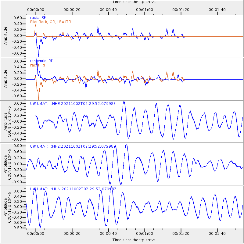
UMAT Pilot Rock, OR, USA - Earthquake Result Viewer
*The percent match for this event was below the threshold and hence no stack was calculated.
| Earthquake location: |
Solomon Islands |
| Earthquake latitude/longitude: |
-7.1/154.8 |
| Earthquake time(UTC): |
2021/10/02 (275) 02:17:13 GMT |
| Earthquake Depth: |
10 km |
| Earthquake Magnitude: |
5.4 Mww |
| Earthquake Catalog/Contributor: |
NEIC PDE/us |
|
| Network: |
UW Pacific Northwest Regional Seismic Network |
| Station: |
UMAT Pilot Rock, OR, USA |
| Lat/Lon: |
45.29 N/118.96 W |
| Elevation: |
1318 m |
|
| Distance: |
92.4 deg |
| Az: |
44.828 deg |
| Baz: |
262.343 deg |
| Ray Param: |
$rayparam |
*The percent match for this event was below the threshold and hence was not used in the summary stack. |
|
| Radial Match: |
71.81725 % |
| Radial Bump: |
400 |
| Transverse Match: |
59.822784 % |
| Transverse Bump: |
342 |
| SOD ConfigId: |
25131211 |
| Insert Time: |
2021-10-16 02:28:52.762 +0000 |
| GWidth: |
2.5 |
| Max Bumps: |
400 |
| Tol: |
0.001 |
|
Signal To Noise
| Channel | StoN | STA | LTA |
| UW:UMAT: :HHZ:20211002T02:29:52.07998Z | 0.9430637 | 1.5322857E-7 | 1.6247955E-7 |
| UW:UMAT: :HHN:20211002T02:29:52.07998Z | 2.3332114 | 5.08071E-7 | 2.177561E-7 |
| UW:UMAT: :HHE:20211002T02:29:52.07998Z | 0.72709286 | 1.1697473E-7 | 1.6088005E-7 |
| Arrivals |
| Ps | |
| PpPs | |
| PsPs/PpSs | |


