You are here: Home > Network List > AK - Alaska Regional Network Stations List
> Station EYAK Cordova Ski Area > Earthquake Result Viewer
EYAK Cordova Ski Area - Earthquake Result Viewer
| Earthquake location: |
East Of Kuril Islands |
| Earthquake latitude/longitude: |
44.9/150.4 |
| Earthquake time(UTC): |
2006/04/07 (097) 15:00:02 GMT |
| Earthquake Depth: |
65 km |
| Earthquake Magnitude: |
5.5 MB, 5.5 MW, 5.3 MW |
| Earthquake Catalog/Contributor: |
WHDF/NEIC |
|
| Network: |
AK Alaska Regional Network |
| Station: |
EYAK Cordova Ski Area |
| Lat/Lon: |
60.55 N/145.75 W |
| Elevation: |
146 m |
|
| Distance: |
40.0 deg |
| Az: |
43.654 deg |
| Baz: |
276.738 deg |
| Ray Param: |
0.074462414 |
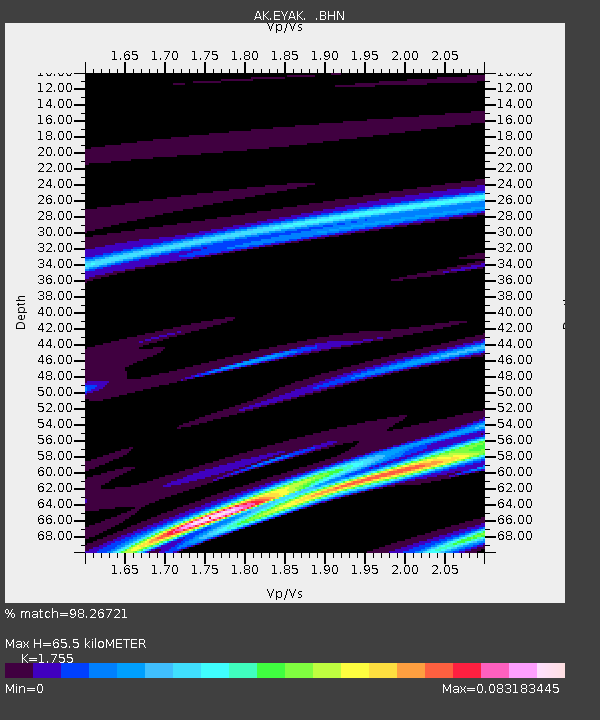
| Estimated Moho Depth: |
65.5 km |
| Estimated Crust Vp/Vs: |
1.75 |
| Assumed Crust Vp: |
6.566 km/s |
| Estimated Crust Vs: |
3.741 km/s |
| Estimated Crust Poisson's Ratio: |
0.26 |
|
| Radial Match: |
98.26721 % |
| Radial Bump: |
84 |
| Transverse Match: |
98.56685 % |
| Transverse Bump: |
83 |
| SOD ConfigId: |
2669 |
| Insert Time: |
2010-03-09 13:12:49.007 +0000 |
| GWidth: |
2.5 |
| Max Bumps: |
400 |
| Tol: |
0.001 |
|

Signal To Noise
| Channel | StoN | STA | LTA |
| AK:EYAK: :BHN:20060407T15:07:00.059015Z | 1.4760658 | 3.23802E-7 | 2.1936826E-7 |
| AK:EYAK: :BHE:20060407T15:07:00.059015Z | 2.3075867 | 5.3107567E-7 | 2.3014333E-7 |
| AK:EYAK: :BHZ:20060407T15:07:00.059015Z | 4.2953095 | 7.497979E-7 | 1.74562E-7 |
| Arrivals |
| Ps | 8.1 SECOND |
| PpPs | 26 SECOND |
| PsPs/PpSs | 34 SECOND |


