You are here: Home > Network List > CI - Caltech Regional Seismic Network Stations List
> Station MPM Manuel Prospect Mine, California, USA > Earthquake Result Viewer
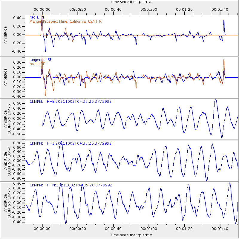
MPM Manuel Prospect Mine, California, USA - Earthquake Result Viewer
*The percent match for this event was below the threshold and hence no stack was calculated.
| Earthquake location: |
Samoa Islands Region |
| Earthquake latitude/longitude: |
-14.9/-173.1 |
| Earthquake time(UTC): |
2021/10/02 (275) 04:24:28 GMT |
| Earthquake Depth: |
10 km |
| Earthquake Magnitude: |
5.7 Mww |
| Earthquake Catalog/Contributor: |
NEIC PDE/us |
|
| Network: |
CI Caltech Regional Seismic Network |
| Station: |
MPM Manuel Prospect Mine, California, USA |
| Lat/Lon: |
36.06 N/117.49 W |
| Elevation: |
185 m |
|
| Distance: |
73.0 deg |
| Az: |
44.377 deg |
| Baz: |
236.564 deg |
| Ray Param: |
$rayparam |
*The percent match for this event was below the threshold and hence was not used in the summary stack. |
|
| Radial Match: |
73.90405 % |
| Radial Bump: |
400 |
| Transverse Match: |
25.58892 % |
| Transverse Bump: |
390 |
| SOD ConfigId: |
25131211 |
| Insert Time: |
2021-10-16 04:30:39.846 +0000 |
| GWidth: |
2.5 |
| Max Bumps: |
400 |
| Tol: |
0.001 |
|
Signal To Noise
| Channel | StoN | STA | LTA |
| CI:MPM: :HHZ:20211002T04:35:26.377999Z | 3.9218955 | 4.114596E-7 | 1.04913454E-7 |
| CI:MPM: :HHN:20211002T04:35:26.377999Z | 0.89247036 | 1.1985658E-7 | 1.3429755E-7 |
| CI:MPM: :HHE:20211002T04:35:26.377999Z | 1.108856 | 2.4508563E-7 | 2.2102567E-7 |
| Arrivals |
| Ps | |
| PpPs | |
| PsPs/PpSs | |


