You are here: Home > Network List > AK - Alaska Regional Network Stations List
> Station EYAK Cordova Ski Area > Earthquake Result Viewer
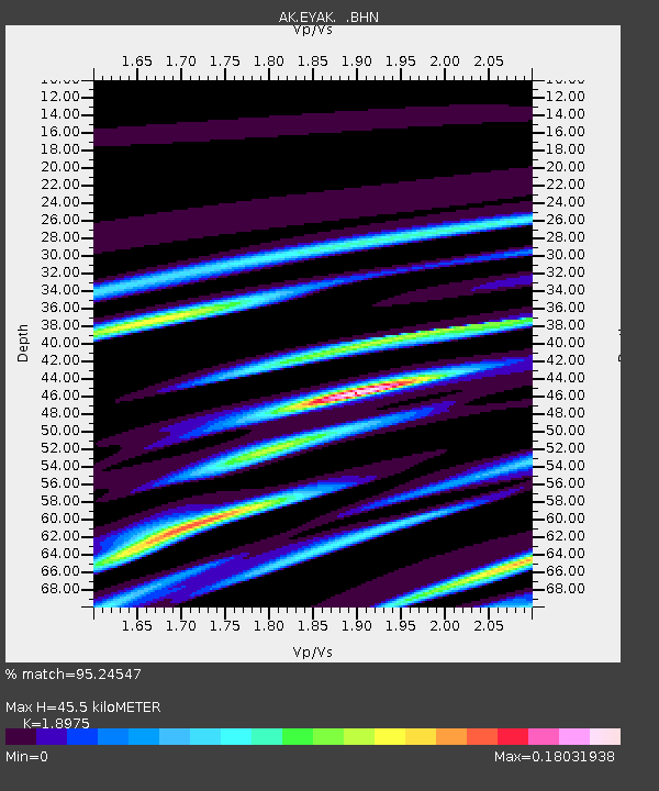
EYAK Cordova Ski Area - Earthquake Result Viewer
| Earthquake location: |
Kermadec Islands Region |
| Earthquake latitude/longitude: |
-29.6/-176.8 |
| Earthquake time(UTC): |
2006/03/31 (090) 13:21:00 GMT |
| Earthquake Depth: |
17 km |
| Earthquake Magnitude: |
5.9 MB, 6.7 MS, 6.5 MW, 6.5 MW |
| Earthquake Catalog/Contributor: |
WHDF/NEIC |
|
| Network: |
AK Alaska Regional Network |
| Station: |
EYAK Cordova Ski Area |
| Lat/Lon: |
60.55 N/145.75 W |
| Elevation: |
146 m |
|
| Distance: |
93.4 deg |
| Az: |
14.805 deg |
| Baz: |
206.763 deg |
| Ray Param: |
0.04127126 |
| Estimated Moho Depth: |
45.5 km |
| Estimated Crust Vp/Vs: |
1.90 |
| Assumed Crust Vp: |
6.566 km/s |
| Estimated Crust Vs: |
3.46 km/s |
| Estimated Crust Poisson's Ratio: |
0.31 |
|
| Radial Match: |
95.24547 % |
| Radial Bump: |
103 |
| Transverse Match: |
86.15898 % |
| Transverse Bump: |
151 |
| SOD ConfigId: |
2669 |
| Insert Time: |
2010-03-09 13:12:53.805 +0000 |
| GWidth: |
2.5 |
| Max Bumps: |
400 |
| Tol: |
0.001 |
|

Signal To Noise
| Channel | StoN | STA | LTA |
| AK:EYAK: :BHN:20060331T13:33:42.800002Z | 0.9497063 | 3.2798425E-7 | 3.4535336E-7 |
| AK:EYAK: :BHE:20060331T13:33:42.800002Z | 0.5994838 | 1.6484911E-7 | 2.7498513E-7 |
| AK:EYAK: :BHZ:20060331T13:33:42.800002Z | 1.2189194 | 2.7511516E-7 | 2.2570413E-7 |
| Arrivals |
| Ps | 6.3 SECOND |
| PpPs | 20 SECOND |
| PsPs/PpSs | 26 SECOND |


