You are here: Home > Network List > AK - Alaska Regional Network Stations List
> Station EYAK Cordova Ski Area > Earthquake Result Viewer
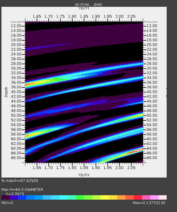
EYAK Cordova Ski Area - Earthquake Result Viewer
| Earthquake location: |
Banda Sea |
| Earthquake latitude/longitude: |
-7.5/125.1 |
| Earthquake time(UTC): |
2006/03/17 (076) 13:07:20 GMT |
| Earthquake Depth: |
384 km |
| Earthquake Magnitude: |
5.2 MB, 5.6 MW, 5.6 MW |
| Earthquake Catalog/Contributor: |
WHDF/NEIC |
|
| Network: |
AK Alaska Regional Network |
| Station: |
EYAK Cordova Ski Area |
| Lat/Lon: |
60.55 N/145.75 W |
| Elevation: |
146 m |
|
| Distance: |
96.0 deg |
| Az: |
29.795 deg |
| Baz: |
265.607 deg |
| Ray Param: |
0.040252343 |
| Estimated Moho Depth: |
64.0 km |
| Estimated Crust Vp/Vs: |
2.10 |
| Assumed Crust Vp: |
6.566 km/s |
| Estimated Crust Vs: |
3.13 km/s |
| Estimated Crust Poisson's Ratio: |
0.35 |
|
| Radial Match: |
97.62505 % |
| Radial Bump: |
102 |
| Transverse Match: |
96.74505 % |
| Transverse Bump: |
96 |
| SOD ConfigId: |
2669 |
| Insert Time: |
2010-03-09 13:12:58.686 +0000 |
| GWidth: |
2.5 |
| Max Bumps: |
400 |
| Tol: |
0.001 |
|

Signal To Noise
| Channel | StoN | STA | LTA |
| AK:EYAK: :BHN:20060317T13:19:33.679009Z | 1.0756882 | 3.791676E-7 | 3.5248837E-7 |
| AK:EYAK: :BHE:20060317T13:19:33.679009Z | 0.7374818 | 1.814281E-7 | 2.460103E-7 |
| AK:EYAK: :BHZ:20060317T13:19:33.679009Z | 1.0588217 | 2.3420034E-7 | 2.2118961E-7 |
| Arrivals |
| Ps | 11 SECOND |
| PpPs | 30 SECOND |
| PsPs/PpSs | 41 SECOND |


