You are here: Home > Network List > AK - Alaska Regional Network Stations List
> Station EYAK Cordova Ski Area > Earthquake Result Viewer
EYAK Cordova Ski Area - Earthquake Result Viewer
| Earthquake location: |
South Of Mariana Islands |
| Earthquake latitude/longitude: |
14.0/146.3 |
| Earthquake time(UTC): |
2005/11/30 (334) 04:54:27 GMT |
| Earthquake Depth: |
10 km |
| Earthquake Magnitude: |
5.5 MB, 5.0 MW |
| Earthquake Catalog/Contributor: |
WHDF/NEIC |
|
| Network: |
AK Alaska Regional Network |
| Station: |
EYAK Cordova Ski Area |
| Lat/Lon: |
60.55 N/145.75 W |
| Elevation: |
146 m |
|
| Distance: |
67.2 deg |
| Az: |
29.812 deg |
| Baz: |
257.608 deg |
| Ray Param: |
0.057132825 |
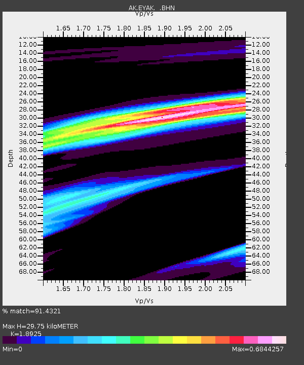
| Estimated Moho Depth: |
29.75 km |
| Estimated Crust Vp/Vs: |
1.89 |
| Assumed Crust Vp: |
6.566 km/s |
| Estimated Crust Vs: |
3.47 km/s |
| Estimated Crust Poisson's Ratio: |
0.31 |
|
| Radial Match: |
91.4321 % |
| Radial Bump: |
202 |
| Transverse Match: |
83.460785 % |
| Transverse Bump: |
209 |
| SOD ConfigId: |
2669 |
| Insert Time: |
2010-03-09 13:13:26.931 +0000 |
| GWidth: |
2.5 |
| Max Bumps: |
400 |
| Tol: |
0.001 |
|

Signal To Noise
| Channel | StoN | STA | LTA |
| AK:EYAK: :BHN:20051130T05:04:50.259011Z | 1.8818953 | 1.2323467E-6 | 6.5484335E-7 |
| AK:EYAK: :BHE:20051130T05:04:50.259011Z | 1.615319 | 5.898259E-7 | 3.6514513E-7 |
| AK:EYAK: :BHZ:20051130T05:04:50.259011Z | 2.1032617 | 9.567829E-7 | 4.5490435E-7 |
| Arrivals |
| Ps | 4.2 SECOND |
| PpPs | 13 SECOND |
| PsPs/PpSs | 17 SECOND |


