You are here: Home > Network List > AU - Australian Seismological Centre Stations List
> Station PSA00 Pilbara Seismic Array Element A0 > Earthquake Result Viewer
PSA00 Pilbara Seismic Array Element A0 - Earthquake Result Viewer
| Earthquake location: |
Vanuatu Islands Region |
| Earthquake latitude/longitude: |
-20.9/174.9 |
| Earthquake time(UTC): |
2021/10/02 (275) 06:29:16 GMT |
| Earthquake Depth: |
486 km |
| Earthquake Magnitude: |
7.2 Mi |
| Earthquake Catalog/Contributor: |
NEIC PDE/pt |
|
| Network: |
AU Australian Seismological Centre |
| Station: |
PSA00 Pilbara Seismic Array Element A0 |
| Lat/Lon: |
21.57 S/119.85 E |
| Elevation: |
305 m |
|
| Distance: |
51.1 deg |
| Az: |
258.653 deg |
| Baz: |
99.91 deg |
| Ray Param: |
0.06552833 |
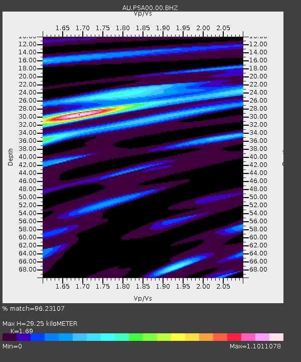
| Estimated Moho Depth: |
29.25 km |
| Estimated Crust Vp/Vs: |
1.69 |
| Assumed Crust Vp: |
6.464 km/s |
| Estimated Crust Vs: |
3.825 km/s |
| Estimated Crust Poisson's Ratio: |
0.23 |
|
| Radial Match: |
96.23107 % |
| Radial Bump: |
334 |
| Transverse Match: |
87.31397 % |
| Transverse Bump: |
400 |
| SOD ConfigId: |
25131211 |
| Insert Time: |
2021-10-16 06:34:45.799 +0000 |
| GWidth: |
2.5 |
| Max Bumps: |
400 |
| Tol: |
0.001 |
|

Signal To Noise
| Channel | StoN | STA | LTA |
| AU:PSA00:00:BHZ:20211002T06:37:02.169006Z | 31.914194 | 2.2936432E-5 | 7.186906E-7 |
| AU:PSA00:00:BH1:20211002T06:37:02.169006Z | 32.793804 | 1.3356958E-5 | 4.0730126E-7 |
| AU:PSA00:00:BH2:20211002T06:37:02.169006Z | 13.568811 | 3.245622E-6 | 2.3919722E-7 |
| Arrivals |
| Ps | 3.3 SECOND |
| PpPs | 12 SECOND |
| PsPs/PpSs | 15 SECOND |


