You are here: Home > Network List > AK - Alaska Regional Network Stations List
> Station EYAK Cordova Ski Area > Earthquake Result Viewer
EYAK Cordova Ski Area - Earthquake Result Viewer
| Earthquake location: |
Halmahera, Indonesia |
| Earthquake latitude/longitude: |
2.6/128.1 |
| Earthquake time(UTC): |
2005/08/19 (231) 15:48:17 GMT |
| Earthquake Depth: |
36 km |
| Earthquake Magnitude: |
5.5 MB, 5.4 MW, 5.4 MW |
| Earthquake Catalog/Contributor: |
WHDF/NEIC |
|
| Network: |
AK Alaska Regional Network |
| Station: |
EYAK Cordova Ski Area |
| Lat/Lon: |
60.55 N/145.75 W |
| Elevation: |
146 m |
|
| Distance: |
85.8 deg |
| Az: |
29.628 deg |
| Baz: |
267.916 deg |
| Ray Param: |
0.044460066 |
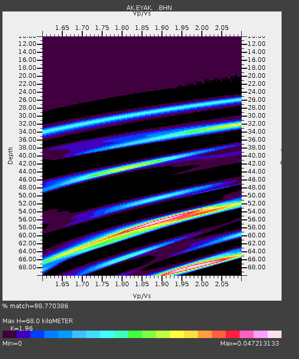
| Estimated Moho Depth: |
68.0 km |
| Estimated Crust Vp/Vs: |
1.96 |
| Assumed Crust Vp: |
6.566 km/s |
| Estimated Crust Vs: |
3.35 km/s |
| Estimated Crust Poisson's Ratio: |
0.32 |
|
| Radial Match: |
98.770386 % |
| Radial Bump: |
64 |
| Transverse Match: |
98.868774 % |
| Transverse Bump: |
65 |
| SOD ConfigId: |
2669 |
| Insert Time: |
2010-03-09 13:13:52.910 +0000 |
| GWidth: |
2.5 |
| Max Bumps: |
400 |
| Tol: |
0.001 |
|

Signal To Noise
| Channel | StoN | STA | LTA |
| AK:EYAK: :BHN:20050819T16:00:21.438997Z | 1.0817554 | 1.5608308E-7 | 1.4428684E-7 |
| AK:EYAK: :BHE:20050819T16:00:21.438997Z | 0.8213114 | 1.3342962E-7 | 1.6245924E-7 |
| AK:EYAK: :BHZ:20050819T16:00:21.438997Z | 1.4870852 | 2.242588E-7 | 1.5080427E-7 |
| Arrivals |
| Ps | 10 SECOND |
| PpPs | 30 SECOND |
| PsPs/PpSs | 40 SECOND |


