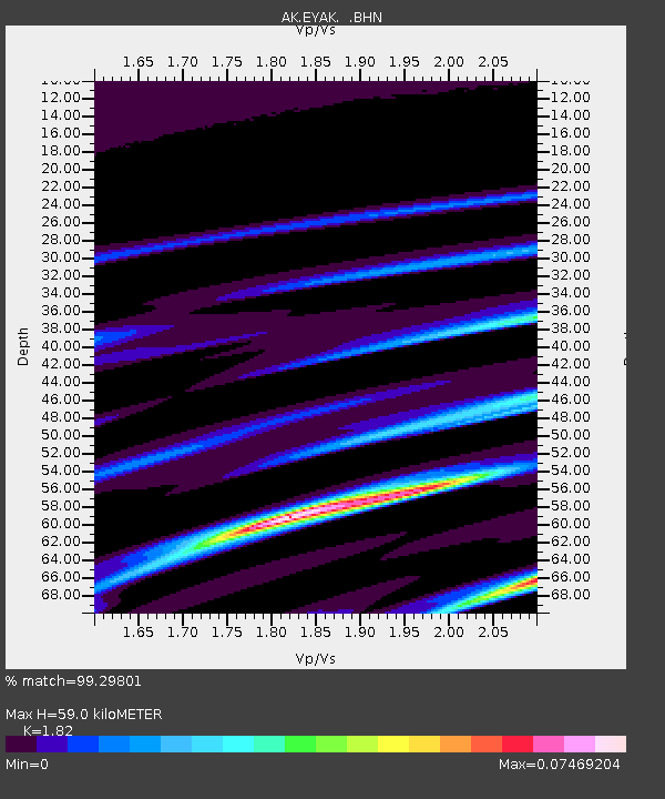
EYAK Cordova Ski Area - Earthquake Result Viewer

Earthquake location: Southern Molucca Sea
Earthquake latitude/longitude: -0.2/125.1
Earthquake time(UTC): 2005/07/18 (199) 19:37:19 GMT
Earthquake Depth: 19 km
Earthquake Magnitude: 5.8 MB, 5.1 MS, 5.9 MW, 5.8 MW
Earthquake Catalog/Contributor: WHDF/NEIC
Network: AK Alaska Regional Network
Station: EYAK Cordova Ski Area
Lat/Lon: 60.55 N/145.75 W
Elevation: 146 m
Distance: 89.7 deg
Az: 29.612 deg
Baz: 269.144 deg
Ray Param: 0.041725107
Estimated Moho Depth: 59.0 km
Estimated Crust Vp/Vs: 1.82
Assumed Crust Vp: 6.566 km/s
Estimated Crust Vs: 3.608 km/s
Estimated Crust Poisson's Ratio: 0.28
Radial Match: 99.29801 %
Radial Bump: 74
Transverse Match: 99.15331 %
Transverse Bump: 74
SOD ConfigId: 2669
Insert Time: 2010-03-09 13:14:07.573 +0000
GWidth: 2.5
Max Bumps: 400
Tol: 0.001

Signal To Noise

ChannelStoNSTALTA
AK:EYAK: :BHN:20050718T19:49:44.618994Z0.95010761.1841846E-71.246369E-7
AK:EYAK: :BHE:20050718T19:49:44.618994Z1.00065881.5037051E-71.5027152E-7
AK:EYAK: :BHZ:20050718T19:49:44.618994Z1.58411981.7214481E-71.0866906E-7
Arrivals
Ps7.5 SECOND
PpPs25 SECOND
PsPs/PpSs32 SECOND