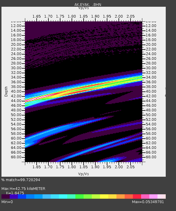
EYAK Cordova Ski Area - Earthquake Result Viewer

Earthquake location: Tanimbar Islands Reg., Indonesia
Earthquake latitude/longitude: -6.8/131.4
Earthquake time(UTC): 2005/07/12 (193) 17:07:19 GMT
Earthquake Depth: 40 km
Earthquake Magnitude: 5.6 MB, 4.9 MS, 5.7 MW, 5.7 MW
Earthquake Catalog/Contributor: WHDF/NEIC
Network: AK Alaska Regional Network
Station: EYAK Cordova Ski Area
Lat/Lon: 60.55 N/145.75 W
Elevation: 146 m
Distance: 92.4 deg
Az: 29.391 deg
Baz: 260.444 deg
Ray Param: 0.041454382
Estimated Moho Depth: 42.75 km
Estimated Crust Vp/Vs: 1.65
Assumed Crust Vp: 6.566 km/s
Estimated Crust Vs: 3.986 km/s
Estimated Crust Poisson's Ratio: 0.21
Radial Match: 99.728294 %
Radial Bump: 37
Transverse Match: 99.59155 %
Transverse Bump: 40
SOD ConfigId: 2669
Insert Time: 2010-03-09 13:14:10.325 +0000
GWidth: 2.5
Max Bumps: 400
Tol: 0.001

Signal To Noise

ChannelStoNSTALTA
AK:EYAK: :BHN:20050712T17:19:54.918999Z0.658450668.343709E-81.267173E-7
AK:EYAK: :BHE:20050712T17:19:54.918999Z0.83410161.0404199E-71.2473538E-7
AK:EYAK: :BHZ:20050712T17:19:54.918999Z0.476397635.865745E-81.2312708E-7
Arrivals
Ps4.3 SECOND
PpPs17 SECOND
PsPs/PpSs21 SECOND