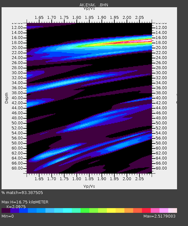
EYAK Cordova Ski Area - Earthquake Result Viewer

Earthquake location: Near East Coast Of Honshu, Japan
Earthquake latitude/longitude: 38.3/142.0
Earthquake time(UTC): 2005/08/16 (228) 02:46:28 GMT
Earthquake Depth: 36 km
Earthquake Magnitude: 6.5 MB, 6.8 MS, 7.2 MW, 7.1 MW
Earthquake Catalog/Contributor: WHDF/NEIC
Network: AK Alaska Regional Network
Station: EYAK Cordova Ski Area
Lat/Lon: 60.55 N/145.75 W
Elevation: 146 m
Distance: 49.1 deg
Az: 38.522 deg
Baz: 277.287 deg
Ray Param: 0.06886212
Estimated Moho Depth: 16.75 km
Estimated Crust Vp/Vs: 2.10
Assumed Crust Vp: 6.566 km/s
Estimated Crust Vs: 3.13 km/s
Estimated Crust Poisson's Ratio: 0.35
Radial Match: 93.387505 %
Radial Bump: 400
Transverse Match: 91.0241 %
Transverse Bump: 400
SOD ConfigId: 2475
Insert Time: 2010-03-09 13:14:22.810 +0000
GWidth: 2.5
Max Bumps: 400
Tol: 0.001

Signal To Noise

ChannelStoNSTALTA
AK:EYAK: :BHN:20050816T02:54:41.518988Z1.4291751.2895893E-79.023313E-8
AK:EYAK: :BHE:20050816T02:54:41.518988Z11.8053257.5554254E-76.4000155E-8
AK:EYAK: :BHZ:20050816T02:54:41.518988Z23.3346821.3899602E-65.956628E-8
Arrivals
Ps2.9 SECOND
PpPs7.5 SECOND
PsPs/PpSs10 SECOND