You are here: Home > Network List > CI - Caltech Regional Seismic Network Stations List
> Station MPP McPhearson Peak > Earthquake Result Viewer
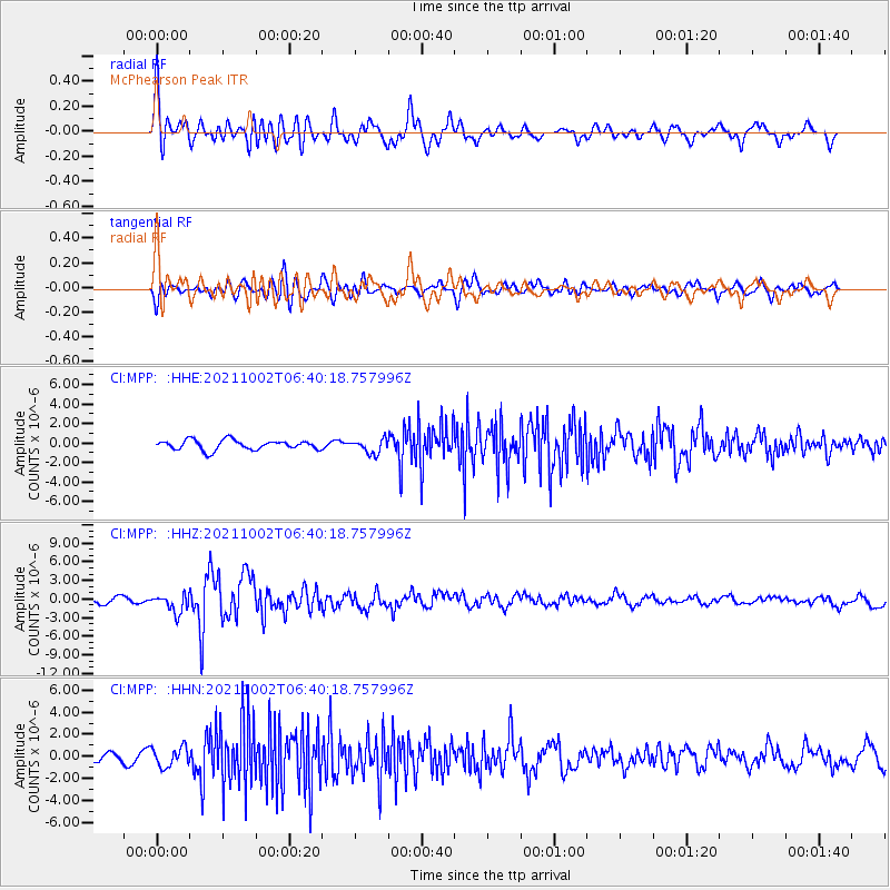
MPP McPhearson Peak - Earthquake Result Viewer
*The percent match for this event was below the threshold and hence no stack was calculated.
| Earthquake location: |
Vanuatu Islands Region |
| Earthquake latitude/longitude: |
-20.9/174.9 |
| Earthquake time(UTC): |
2021/10/02 (275) 06:29:16 GMT |
| Earthquake Depth: |
486 km |
| Earthquake Magnitude: |
7.2 Mi |
| Earthquake Catalog/Contributor: |
NEIC PDE/pt |
|
| Network: |
CI Caltech Regional Seismic Network |
| Station: |
MPP McPhearson Peak |
| Lat/Lon: |
34.89 N/119.81 W |
| Elevation: |
1739 m |
|
| Distance: |
83.1 deg |
| Az: |
48.769 deg |
| Baz: |
238.82 deg |
| Ray Param: |
$rayparam |
*The percent match for this event was below the threshold and hence was not used in the summary stack. |
|
| Radial Match: |
78.48413 % |
| Radial Bump: |
400 |
| Transverse Match: |
59.38206 % |
| Transverse Bump: |
400 |
| SOD ConfigId: |
25131211 |
| Insert Time: |
2021-10-16 06:41:38.884 +0000 |
| GWidth: |
2.5 |
| Max Bumps: |
400 |
| Tol: |
0.001 |
|
Signal To Noise
| Channel | StoN | STA | LTA |
| CI:MPP: :HHZ:20211002T06:40:18.757996Z | 2.839118 | 1.4670331E-6 | 5.1672146E-7 |
| CI:MPP: :HHN:20211002T06:40:18.757996Z | 1.5620575 | 8.8617935E-7 | 5.6731545E-7 |
| CI:MPP: :HHE:20211002T06:40:18.757996Z | 1.4676362 | 7.3888094E-7 | 5.0344966E-7 |
| Arrivals |
| Ps | |
| PpPs | |
| PsPs/PpSs | |


