You are here: Home > Network List > CI - Caltech Regional Seismic Network Stations List
> Station TIN Tinemaha, Big Pine, CA, USA > Earthquake Result Viewer
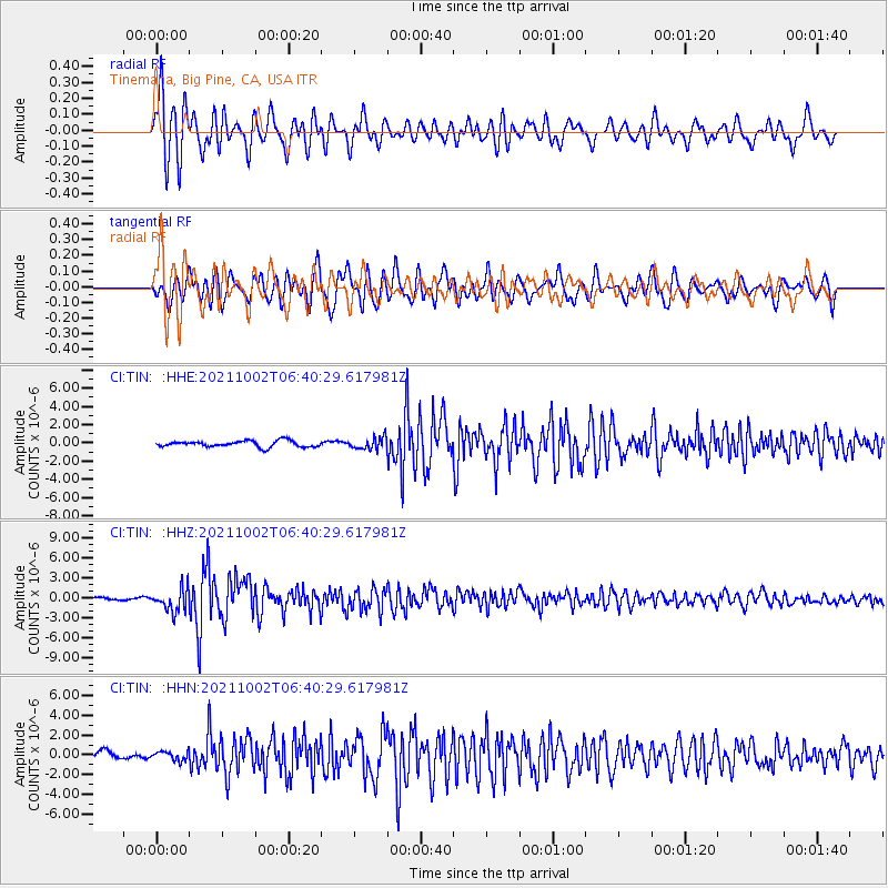
TIN Tinemaha, Big Pine, CA, USA - Earthquake Result Viewer
*The percent match for this event was below the threshold and hence no stack was calculated.
| Earthquake location: |
Vanuatu Islands Region |
| Earthquake latitude/longitude: |
-20.9/174.9 |
| Earthquake time(UTC): |
2021/10/02 (275) 06:29:16 GMT |
| Earthquake Depth: |
486 km |
| Earthquake Magnitude: |
7.2 Mi |
| Earthquake Catalog/Contributor: |
NEIC PDE/pt |
|
| Network: |
CI Caltech Regional Seismic Network |
| Station: |
TIN Tinemaha, Big Pine, CA, USA |
| Lat/Lon: |
37.05 N/118.23 W |
| Elevation: |
1197 m |
|
| Distance: |
85.3 deg |
| Az: |
47.563 deg |
| Baz: |
239.624 deg |
| Ray Param: |
$rayparam |
*The percent match for this event was below the threshold and hence was not used in the summary stack. |
|
| Radial Match: |
74.36415 % |
| Radial Bump: |
400 |
| Transverse Match: |
65.794 % |
| Transverse Bump: |
400 |
| SOD ConfigId: |
25131211 |
| Insert Time: |
2021-10-16 06:42:14.923 +0000 |
| GWidth: |
2.5 |
| Max Bumps: |
400 |
| Tol: |
0.001 |
|
Signal To Noise
| Channel | StoN | STA | LTA |
| CI:TIN: :HHZ:20211002T06:40:29.617981Z | 8.796292 | 1.6823976E-6 | 1.9126212E-7 |
| CI:TIN: :HHN:20211002T06:40:29.617981Z | 1.0064223 | 4.6527867E-7 | 4.6230963E-7 |
| CI:TIN: :HHE:20211002T06:40:29.617981Z | 1.9267765 | 6.546585E-7 | 3.3976875E-7 |
| Arrivals |
| Ps | |
| PpPs | |
| PsPs/PpSs | |


