You are here: Home > Network List > IW - Intermountain West Stations List
> Station MOOW Moose Ponds, Wyoming, USA > Earthquake Result Viewer
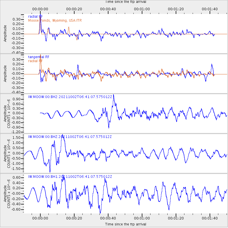
MOOW Moose Ponds, Wyoming, USA - Earthquake Result Viewer
*The percent match for this event was below the threshold and hence no stack was calculated.
| Earthquake location: |
Vanuatu Islands Region |
| Earthquake latitude/longitude: |
-20.9/174.9 |
| Earthquake time(UTC): |
2021/10/02 (275) 06:29:16 GMT |
| Earthquake Depth: |
486 km |
| Earthquake Magnitude: |
7.2 Mi |
| Earthquake Catalog/Contributor: |
NEIC PDE/pt |
|
| Network: |
IW Intermountain West |
| Station: |
MOOW Moose Ponds, Wyoming, USA |
| Lat/Lon: |
43.75 N/110.74 W |
| Elevation: |
2128 m |
|
| Distance: |
93.5 deg |
| Az: |
44.352 deg |
| Baz: |
244.436 deg |
| Ray Param: |
$rayparam |
*The percent match for this event was below the threshold and hence was not used in the summary stack. |
|
| Radial Match: |
78.246315 % |
| Radial Bump: |
400 |
| Transverse Match: |
76.60471 % |
| Transverse Bump: |
400 |
| SOD ConfigId: |
25131211 |
| Insert Time: |
2021-10-16 06:45:24.556 +0000 |
| GWidth: |
2.5 |
| Max Bumps: |
400 |
| Tol: |
0.001 |
|
Signal To Noise
| Channel | StoN | STA | LTA |
| IW:MOOW:00:BHZ:20211002T06:41:07.575012Z | 4.212085 | 7.5664263E-7 | 1.7963613E-7 |
| IW:MOOW:00:BH1:20211002T06:41:07.575012Z | 1.1505932 | 2.4451958E-7 | 2.125161E-7 |
| IW:MOOW:00:BH2:20211002T06:41:07.575012Z | 2.1019642 | 2.9165008E-7 | 1.3875122E-7 |
| Arrivals |
| Ps | |
| PpPs | |
| PsPs/PpSs | |


