You are here: Home > Network List > AK - Alaska Regional Network Stations List
> Station EYAK Cordova Ski Area > Earthquake Result Viewer
EYAK Cordova Ski Area - Earthquake Result Viewer
| Earthquake location: |
Banda Sea |
| Earthquake latitude/longitude: |
-6.7/130.9 |
| Earthquake time(UTC): |
2007/06/06 (157) 11:28:24 GMT |
| Earthquake Depth: |
87 km |
| Earthquake Magnitude: |
5.8 MB, 5.8 MW, 5.8 MW |
| Earthquake Catalog/Contributor: |
WHDF/NEIC |
|
| Network: |
AK Alaska Regional Network |
| Station: |
EYAK Cordova Ski Area |
| Lat/Lon: |
60.55 N/145.75 W |
| Elevation: |
146 m |
|
| Distance: |
92.5 deg |
| Az: |
29.428 deg |
| Baz: |
260.928 deg |
| Ray Param: |
0.04139445 |
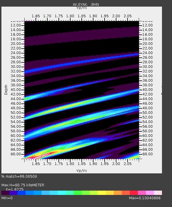
| Estimated Moho Depth: |
68.75 km |
| Estimated Crust Vp/Vs: |
1.67 |
| Assumed Crust Vp: |
6.566 km/s |
| Estimated Crust Vs: |
3.926 km/s |
| Estimated Crust Poisson's Ratio: |
0.22 |
|
| Radial Match: |
99.08508 % |
| Radial Bump: |
74 |
| Transverse Match: |
98.62731 % |
| Transverse Bump: |
76 |
| SOD ConfigId: |
2564 |
| Insert Time: |
2010-03-09 13:14:55.218 +0000 |
| GWidth: |
2.5 |
| Max Bumps: |
400 |
| Tol: |
0.001 |
|

Signal To Noise
| Channel | StoN | STA | LTA |
| AK:EYAK: :BHN:20070606T11:40:55.300017Z | 1.0271406 | 2.0636959E-7 | 2.009166E-7 |
| AK:EYAK: :BHE:20070606T11:40:55.300017Z | 0.5316489 | 9.858069E-8 | 1.8542444E-7 |
| AK:EYAK: :BHZ:20070606T11:40:55.300017Z | 0.9567047 | 1.5767314E-7 | 1.6480858E-7 |
| Arrivals |
| Ps | 7.2 SECOND |
| PpPs | 27 SECOND |
| PsPs/PpSs | 35 SECOND |


