You are here: Home > Network List > AK - Alaska Regional Network Stations List
> Station EYAK Cordova Ski Area > Earthquake Result Viewer
EYAK Cordova Ski Area - Earthquake Result Viewer
| Earthquake location: |
Halmahera, Indonesia |
| Earthquake latitude/longitude: |
-1.1/127.4 |
| Earthquake time(UTC): |
2007/05/29 (149) 09:42:58 GMT |
| Earthquake Depth: |
10 km |
| Earthquake Magnitude: |
5.5 MB |
| Earthquake Catalog/Contributor: |
WHDF/NEIC |
|
| Network: |
AK Alaska Regional Network |
| Station: |
EYAK Cordova Ski Area |
| Lat/Lon: |
60.55 N/145.75 W |
| Elevation: |
146 m |
|
| Distance: |
89.4 deg |
| Az: |
29.568 deg |
| Baz: |
266.723 deg |
| Ray Param: |
0.041909486 |
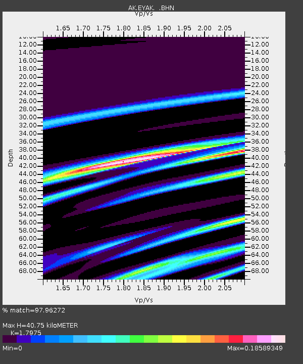
| Estimated Moho Depth: |
40.75 km |
| Estimated Crust Vp/Vs: |
1.80 |
| Assumed Crust Vp: |
6.566 km/s |
| Estimated Crust Vs: |
3.653 km/s |
| Estimated Crust Poisson's Ratio: |
0.28 |
|
| Radial Match: |
97.96272 % |
| Radial Bump: |
109 |
| Transverse Match: |
97.08588 % |
| Transverse Bump: |
110 |
| SOD ConfigId: |
2564 |
| Insert Time: |
2010-03-09 13:14:56.335 +0000 |
| GWidth: |
2.5 |
| Max Bumps: |
400 |
| Tol: |
0.001 |
|

Signal To Noise
| Channel | StoN | STA | LTA |
| AK:EYAK: :BHN:20070529T09:55:23.499001Z | 1.8797735 | 3.8431878E-7 | 2.044495E-7 |
| AK:EYAK: :BHE:20070529T09:55:23.499001Z | 1.205338 | 2.644765E-7 | 2.1942103E-7 |
| AK:EYAK: :BHZ:20070529T09:55:23.499001Z | 0.5638363 | 1.5426677E-7 | 2.7360207E-7 |
| Arrivals |
| Ps | 5.1 SECOND |
| PpPs | 17 SECOND |
| PsPs/PpSs | 22 SECOND |


