You are here: Home > Network List > AK - Alaska Regional Network Stations List
> Station EYAK Cordova Ski Area > Earthquake Result Viewer
EYAK Cordova Ski Area - Earthquake Result Viewer
| Earthquake location: |
Seram, Indonesia |
| Earthquake latitude/longitude: |
-3.5/127.3 |
| Earthquake time(UTC): |
2007/05/12 (132) 12:58:11 GMT |
| Earthquake Depth: |
59 km |
| Earthquake Magnitude: |
5.5 MB, 5.3 MW, 5.3 MW |
| Earthquake Catalog/Contributor: |
WHDF/NEIC |
|
| Network: |
AK Alaska Regional Network |
| Station: |
EYAK Cordova Ski Area |
| Lat/Lon: |
60.55 N/145.75 W |
| Elevation: |
146 m |
|
| Distance: |
91.5 deg |
| Az: |
29.582 deg |
| Baz: |
265.697 deg |
| Ray Param: |
0.041578572 |
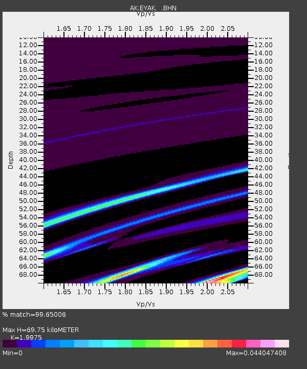
| Estimated Moho Depth: |
69.75 km |
| Estimated Crust Vp/Vs: |
2.00 |
| Assumed Crust Vp: |
6.566 km/s |
| Estimated Crust Vs: |
3.287 km/s |
| Estimated Crust Poisson's Ratio: |
0.33 |
|
| Radial Match: |
99.65006 % |
| Radial Bump: |
49 |
| Transverse Match: |
99.36015 % |
| Transverse Bump: |
51 |
| SOD ConfigId: |
2564 |
| Insert Time: |
2010-03-09 13:15:02.347 +0000 |
| GWidth: |
2.5 |
| Max Bumps: |
400 |
| Tol: |
0.001 |
|

Signal To Noise
| Channel | StoN | STA | LTA |
| AK:EYAK: :BHN:20070512T13:10:39.860017Z | 0.57943577 | 6.8522695E-8 | 1.1825762E-7 |
| AK:EYAK: :BHE:20070512T13:10:39.860017Z | 0.9741241 | 1.0920142E-7 | 1.12102164E-7 |
| AK:EYAK: :BHZ:20070512T13:10:39.860017Z | 0.9183535 | 9.8603316E-8 | 1.0736967E-7 |
| Arrivals |
| Ps | 11 SECOND |
| PpPs | 31 SECOND |
| PsPs/PpSs | 42 SECOND |


