You are here: Home > Network List > S1 - Australian Seismometers in Schools Stations List
> Station AUCAS Cummins Area School > Earthquake Result Viewer
AUCAS Cummins Area School - Earthquake Result Viewer
| Earthquake location: |
Vanuatu Islands Region |
| Earthquake latitude/longitude: |
-20.9/174.9 |
| Earthquake time(UTC): |
2021/10/02 (275) 06:29:16 GMT |
| Earthquake Depth: |
486 km |
| Earthquake Magnitude: |
7.2 Mi |
| Earthquake Catalog/Contributor: |
NEIC PDE/pt |
|
| Network: |
S1 Australian Seismometers in Schools |
| Station: |
AUCAS Cummins Area School |
| Lat/Lon: |
34.26 S/135.72 E |
| Elevation: |
72 m |
|
| Distance: |
37.0 deg |
| Az: |
240.449 deg |
| Baz: |
79.196 deg |
| Ray Param: |
0.074094646 |
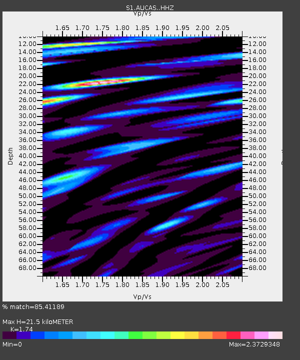
| Estimated Moho Depth: |
21.5 km |
| Estimated Crust Vp/Vs: |
1.74 |
| Assumed Crust Vp: |
6.134 km/s |
| Estimated Crust Vs: |
3.525 km/s |
| Estimated Crust Poisson's Ratio: |
0.25 |
|
| Radial Match: |
85.41189 % |
| Radial Bump: |
400 |
| Transverse Match: |
54.894714 % |
| Transverse Bump: |
400 |
| SOD ConfigId: |
25131211 |
| Insert Time: |
2021-10-16 06:48:37.508 +0000 |
| GWidth: |
2.5 |
| Max Bumps: |
400 |
| Tol: |
0.001 |
|

Signal To Noise
| Channel | StoN | STA | LTA |
| S1:AUCAS: :HHZ:20211002T06:35:12.709991Z | 73.87272 | 2.8371003E-5 | 3.8405253E-7 |
| S1:AUCAS: :HHN:20211002T06:35:12.709991Z | 14.636886 | 1.3641656E-5 | 9.320053E-7 |
| S1:AUCAS: :HHE:20211002T06:35:12.709991Z | 51.850124 | 3.685084E-5 | 7.1071844E-7 |
| Arrivals |
| Ps | 2.8 SECOND |
| PpPs | 9.0 SECOND |
| PsPs/PpSs | 12 SECOND |


