You are here: Home > Network List > S1 - Australian Seismometers in Schools Stations List
> Station AUMBR Murray Bridge High School > Earthquake Result Viewer
AUMBR Murray Bridge High School - Earthquake Result Viewer
| Earthquake location: |
Vanuatu Islands Region |
| Earthquake latitude/longitude: |
-20.9/174.9 |
| Earthquake time(UTC): |
2021/10/02 (275) 06:29:16 GMT |
| Earthquake Depth: |
486 km |
| Earthquake Magnitude: |
7.2 Mi |
| Earthquake Catalog/Contributor: |
NEIC PDE/pt |
|
| Network: |
S1 Australian Seismometers in Schools |
| Station: |
AUMBR Murray Bridge High School |
| Lat/Lon: |
35.13 S/139.29 E |
| Elevation: |
50 m |
|
| Distance: |
34.3 deg |
| Az: |
237.876 deg |
| Baz: |
75.086 deg |
| Ray Param: |
0.07559 |
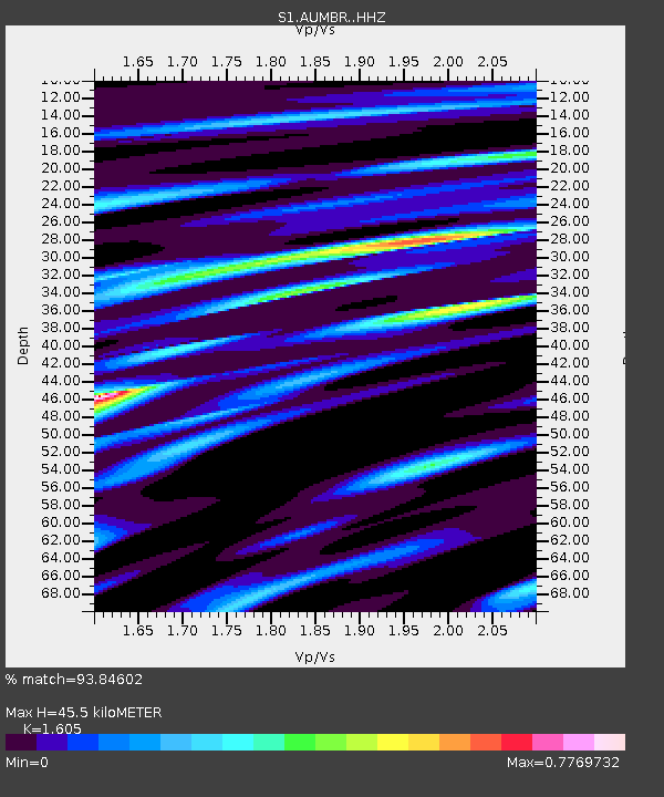
| Estimated Moho Depth: |
45.5 km |
| Estimated Crust Vp/Vs: |
1.61 |
| Assumed Crust Vp: |
6.576 km/s |
| Estimated Crust Vs: |
4.097 km/s |
| Estimated Crust Poisson's Ratio: |
0.18 |
|
| Radial Match: |
93.84602 % |
| Radial Bump: |
220 |
| Transverse Match: |
79.72042 % |
| Transverse Bump: |
400 |
| SOD ConfigId: |
25131211 |
| Insert Time: |
2021-10-16 06:48:47.229 +0000 |
| GWidth: |
2.5 |
| Max Bumps: |
400 |
| Tol: |
0.001 |
|

Signal To Noise
| Channel | StoN | STA | LTA |
| S1:AUMBR: :HHZ:20211002T06:34:50.51001Z | 125.18379 | 3.389997E-5 | 2.708016E-7 |
| S1:AUMBR: :HHN:20211002T06:34:50.51001Z | 26.725727 | 1.1407296E-5 | 4.2682828E-7 |
| S1:AUMBR: :HHE:20211002T06:34:50.51001Z | 59.773125 | 1.8827668E-5 | 3.149855E-7 |
| Arrivals |
| Ps | 4.6 SECOND |
| PpPs | 17 SECOND |
| PsPs/PpSs | 21 SECOND |


