You are here: Home > Network List > UO - University of Oregon Regional Network Stations List
> Station VINO Umpqua, OR, USA > Earthquake Result Viewer
VINO Umpqua, OR, USA - Earthquake Result Viewer
| Earthquake location: |
Vanuatu Islands Region |
| Earthquake latitude/longitude: |
-20.9/174.9 |
| Earthquake time(UTC): |
2021/10/02 (275) 06:29:16 GMT |
| Earthquake Depth: |
486 km |
| Earthquake Magnitude: |
7.2 Mi |
| Earthquake Catalog/Contributor: |
NEIC PDE/pt |
|
| Network: |
UO University of Oregon Regional Network |
| Station: |
VINO Umpqua, OR, USA |
| Lat/Lon: |
43.43 N/123.42 W |
| Elevation: |
319 m |
|
| Distance: |
85.4 deg |
| Az: |
40.037 deg |
| Baz: |
235.664 deg |
| Ray Param: |
0.043477453 |
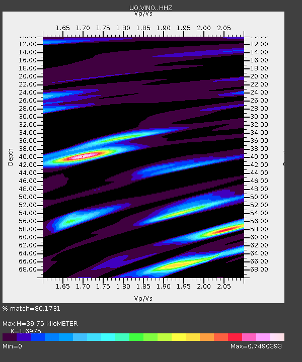
| Estimated Moho Depth: |
39.75 km |
| Estimated Crust Vp/Vs: |
1.70 |
| Assumed Crust Vp: |
6.522 km/s |
| Estimated Crust Vs: |
3.842 km/s |
| Estimated Crust Poisson's Ratio: |
0.23 |
|
| Radial Match: |
80.1731 % |
| Radial Bump: |
400 |
| Transverse Match: |
58.234886 % |
| Transverse Bump: |
400 |
| SOD ConfigId: |
25131211 |
| Insert Time: |
2021-10-16 06:50:42.645 +0000 |
| GWidth: |
2.5 |
| Max Bumps: |
400 |
| Tol: |
0.001 |
|

Signal To Noise
| Channel | StoN | STA | LTA |
| UO:VINO: :HHZ:20211002T06:40:29.840027Z | 3.536231 | 1.5687732E-6 | 4.4362858E-7 |
| UO:VINO: :HHN:20211002T06:40:29.840027Z | 1.5128273 | 9.1067113E-7 | 6.019664E-7 |
| UO:VINO: :HHE:20211002T06:40:29.840027Z | 0.76148134 | 2.3206617E-7 | 3.047562E-7 |
| Arrivals |
| Ps | 4.4 SECOND |
| PpPs | 16 SECOND |
| PsPs/PpSs | 20 SECOND |


