You are here: Home > Network List > US - United States National Seismic Network Stations List
> Station AMTX Amarillo, Texas, USA > Earthquake Result Viewer
AMTX Amarillo, Texas, USA - Earthquake Result Viewer
*The percent match for this event was below the threshold and hence no stack was calculated.
| Earthquake location: |
Vanuatu Islands Region |
| Earthquake latitude/longitude: |
-20.9/174.9 |
| Earthquake time(UTC): |
2021/10/02 (275) 06:29:16 GMT |
| Earthquake Depth: |
486 km |
| Earthquake Magnitude: |
7.2 Mi |
| Earthquake Catalog/Contributor: |
NEIC PDE/pt |
|
| Network: |
US United States National Seismic Network |
| Station: |
AMTX Amarillo, Texas, USA |
| Lat/Lon: |
34.53 N/101.41 W |
| Elevation: |
1010 m |
|
| Distance: |
96.6 deg |
| Az: |
55.691 deg |
| Baz: |
249.332 deg |
| Ray Param: |
$rayparam |
*The percent match for this event was below the threshold and hence was not used in the summary stack. |
|
| Radial Match: |
53.68888 % |
| Radial Bump: |
400 |
| Transverse Match: |
44.232086 % |
| Transverse Bump: |
400 |
| SOD ConfigId: |
25131211 |
| Insert Time: |
2021-10-16 06:50:50.136 +0000 |
| GWidth: |
2.5 |
| Max Bumps: |
400 |
| Tol: |
0.001 |
|
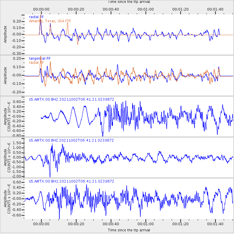
Signal To Noise
| Channel | StoN | STA | LTA |
| US:AMTX:00:BHZ:20211002T06:41:21.023987Z | 2.5590181 | 5.4453346E-7 | 2.1279E-7 |
| US:AMTX:00:BH1:20211002T06:41:21.023987Z | 2.2351413 | 2.272666E-7 | 1.0167885E-7 |
| US:AMTX:00:BH2:20211002T06:41:21.023987Z | 1.1744369 | 2.359693E-7 | 2.0092124E-7 |
| Arrivals |
| Ps | |
| PpPs | |
| PsPs/PpSs | |


