You are here: Home > Network List > US - United States National Seismic Network Stations List
> Station HAWA Hanford, Washington, USA > Earthquake Result Viewer
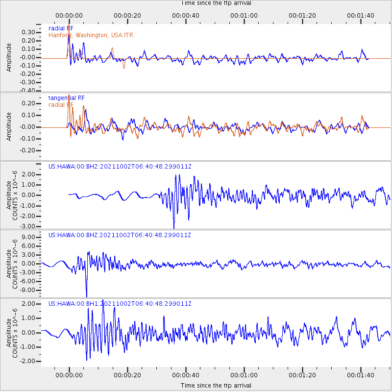
HAWA Hanford, Washington, USA - Earthquake Result Viewer
*The percent match for this event was below the threshold and hence no stack was calculated.
| Earthquake location: |
Vanuatu Islands Region |
| Earthquake latitude/longitude: |
-20.9/174.9 |
| Earthquake time(UTC): |
2021/10/02 (275) 06:29:16 GMT |
| Earthquake Depth: |
486 km |
| Earthquake Magnitude: |
7.2 Mi |
| Earthquake Catalog/Contributor: |
NEIC PDE/pt |
|
| Network: |
US United States National Seismic Network |
| Station: |
HAWA Hanford, Washington, USA |
| Lat/Lon: |
46.39 N/119.53 W |
| Elevation: |
364 m |
|
| Distance: |
89.3 deg |
| Az: |
39.056 deg |
| Baz: |
238.356 deg |
| Ray Param: |
$rayparam |
*The percent match for this event was below the threshold and hence was not used in the summary stack. |
|
| Radial Match: |
75.27292 % |
| Radial Bump: |
399 |
| Transverse Match: |
58.316917 % |
| Transverse Bump: |
398 |
| SOD ConfigId: |
25131211 |
| Insert Time: |
2021-10-16 06:50:58.933 +0000 |
| GWidth: |
2.5 |
| Max Bumps: |
400 |
| Tol: |
0.001 |
|
Signal To Noise
| Channel | StoN | STA | LTA |
| US:HAWA:00:BHZ:20211002T06:40:48.299011Z | 4.0277414 | 1.5654158E-6 | 3.8865844E-7 |
| US:HAWA:00:BH1:20211002T06:40:48.299011Z | 1.1540235 | 3.6718984E-7 | 3.181823E-7 |
| US:HAWA:00:BH2:20211002T06:40:48.299011Z | 2.3137486 | 4.9366315E-7 | 2.1336076E-7 |
| Arrivals |
| Ps | |
| PpPs | |
| PsPs/PpSs | |


