You are here: Home > Network List > UW - Pacific Northwest Regional Seismic Network Stations List
> Station IRON Crane, OR, USA > Earthquake Result Viewer
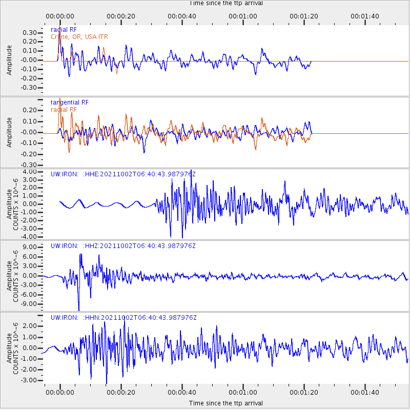
IRON Crane, OR, USA - Earthquake Result Viewer
*The percent match for this event was below the threshold and hence no stack was calculated.
| Earthquake location: |
Vanuatu Islands Region |
| Earthquake latitude/longitude: |
-20.9/174.9 |
| Earthquake time(UTC): |
2021/10/02 (275) 06:29:16 GMT |
| Earthquake Depth: |
486 km |
| Earthquake Magnitude: |
7.2 Mi |
| Earthquake Catalog/Contributor: |
NEIC PDE/pt |
|
| Network: |
UW Pacific Northwest Regional Seismic Network |
| Station: |
IRON Crane, OR, USA |
| Lat/Lon: |
43.36 N/118.47 W |
| Elevation: |
1226 m |
|
| Distance: |
88.4 deg |
| Az: |
42.041 deg |
| Baz: |
239.162 deg |
| Ray Param: |
$rayparam |
*The percent match for this event was below the threshold and hence was not used in the summary stack. |
|
| Radial Match: |
59.39051 % |
| Radial Bump: |
400 |
| Transverse Match: |
58.649776 % |
| Transverse Bump: |
400 |
| SOD ConfigId: |
25131211 |
| Insert Time: |
2021-10-16 06:52:13.222 +0000 |
| GWidth: |
2.5 |
| Max Bumps: |
400 |
| Tol: |
0.001 |
|
Signal To Noise
| Channel | StoN | STA | LTA |
| UW:IRON: :HHZ:20211002T06:40:43.987976Z | 6.2491345 | 1.3812456E-6 | 2.210299E-7 |
| UW:IRON: :HHN:20211002T06:40:43.987976Z | 0.9395191 | 2.5391395E-7 | 2.7025948E-7 |
| UW:IRON: :HHE:20211002T06:40:43.987976Z | 2.1911929 | 5.596079E-7 | 2.553896E-7 |
| Arrivals |
| Ps | |
| PpPs | |
| PsPs/PpSs | |


