You are here: Home > Network List > UW - Pacific Northwest Regional Seismic Network Stations List
> Station UMAT Pilot Rock, OR, USA > Earthquake Result Viewer
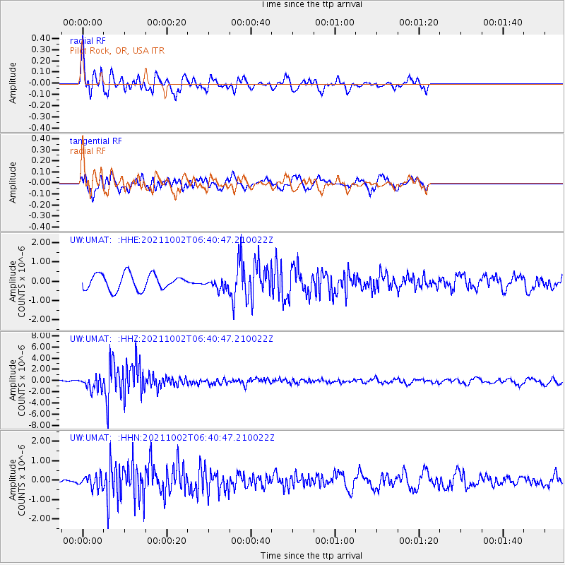
UMAT Pilot Rock, OR, USA - Earthquake Result Viewer
*The percent match for this event was below the threshold and hence no stack was calculated.
| Earthquake location: |
Vanuatu Islands Region |
| Earthquake latitude/longitude: |
-20.9/174.9 |
| Earthquake time(UTC): |
2021/10/02 (275) 06:29:16 GMT |
| Earthquake Depth: |
486 km |
| Earthquake Magnitude: |
7.2 Mi |
| Earthquake Catalog/Contributor: |
NEIC PDE/pt |
|
| Network: |
UW Pacific Northwest Regional Seismic Network |
| Station: |
UMAT Pilot Rock, OR, USA |
| Lat/Lon: |
45.29 N/118.96 W |
| Elevation: |
1318 m |
|
| Distance: |
89.1 deg |
| Az: |
40.205 deg |
| Baz: |
238.783 deg |
| Ray Param: |
$rayparam |
*The percent match for this event was below the threshold and hence was not used in the summary stack. |
|
| Radial Match: |
72.93169 % |
| Radial Bump: |
400 |
| Transverse Match: |
69.43493 % |
| Transverse Bump: |
400 |
| SOD ConfigId: |
25131211 |
| Insert Time: |
2021-10-16 06:53:14.811 +0000 |
| GWidth: |
2.5 |
| Max Bumps: |
400 |
| Tol: |
0.001 |
|
Signal To Noise
| Channel | StoN | STA | LTA |
| UW:UMAT: :HHZ:20211002T06:40:47.210022Z | 3.566511 | 1.241766E-6 | 3.481739E-7 |
| UW:UMAT: :HHN:20211002T06:40:47.210022Z | 1.6237141 | 3.2602412E-7 | 2.0078913E-7 |
| UW:UMAT: :HHE:20211002T06:40:47.210022Z | 0.67095464 | 2.6886624E-7 | 4.0072197E-7 |
| Arrivals |
| Ps | |
| PpPs | |
| PsPs/PpSs | |


