You are here: Home > Network List > AG - Arkansas Seismic Network Stations List
> Station U40A Yellville, AR > Earthquake Result Viewer
U40A Yellville, AR - Earthquake Result Viewer
| Earthquake location: |
Peru-Brazil Border Region |
| Earthquake latitude/longitude: |
-9.6/-71.2 |
| Earthquake time(UTC): |
2021/10/02 (275) 12:52:34 GMT |
| Earthquake Depth: |
589 km |
| Earthquake Magnitude: |
5.9 mww |
| Earthquake Catalog/Contributor: |
NEIC PDE/us |
|
| Network: |
AG Arkansas Seismic Network |
| Station: |
U40A Yellville, AR |
| Lat/Lon: |
36.36 N/92.85 W |
| Elevation: |
374 m |
|
| Distance: |
50.1 deg |
| Az: |
337.121 deg |
| Baz: |
151.643 deg |
| Ray Param: |
0.06556566 |
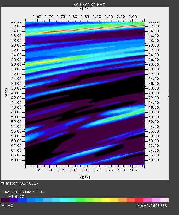
| Estimated Moho Depth: |
12.5 km |
| Estimated Crust Vp/Vs: |
1.91 |
| Assumed Crust Vp: |
6.53 km/s |
| Estimated Crust Vs: |
3.415 km/s |
| Estimated Crust Poisson's Ratio: |
0.31 |
|
| Radial Match: |
82.40307 % |
| Radial Bump: |
400 |
| Transverse Match: |
70.02259 % |
| Transverse Bump: |
400 |
| SOD ConfigId: |
25131211 |
| Insert Time: |
2021-10-16 12:54:03.343 +0000 |
| GWidth: |
2.5 |
| Max Bumps: |
400 |
| Tol: |
0.001 |
|

Signal To Noise
| Channel | StoN | STA | LTA |
| AG:U40A:00:HHZ:20211002T13:00:05.444988Z | 7.9281816 | 2.021947E-6 | 2.550329E-7 |
| AG:U40A:00:HHN:20211002T13:00:05.444988Z | 5.352334 | 1.253027E-6 | 2.3410853E-7 |
| AG:U40A:00:HHE:20211002T13:00:05.444988Z | 11.3135605 | 1.0431087E-6 | 9.2199855E-8 |
| Arrivals |
| Ps | 1.8 SECOND |
| PpPs | 5.3 SECOND |
| PsPs/PpSs | 7.1 SECOND |


