You are here: Home > Network List > AZ - ANZA Regional Network Stations List
> Station SMER AZ.SMER > Earthquake Result Viewer
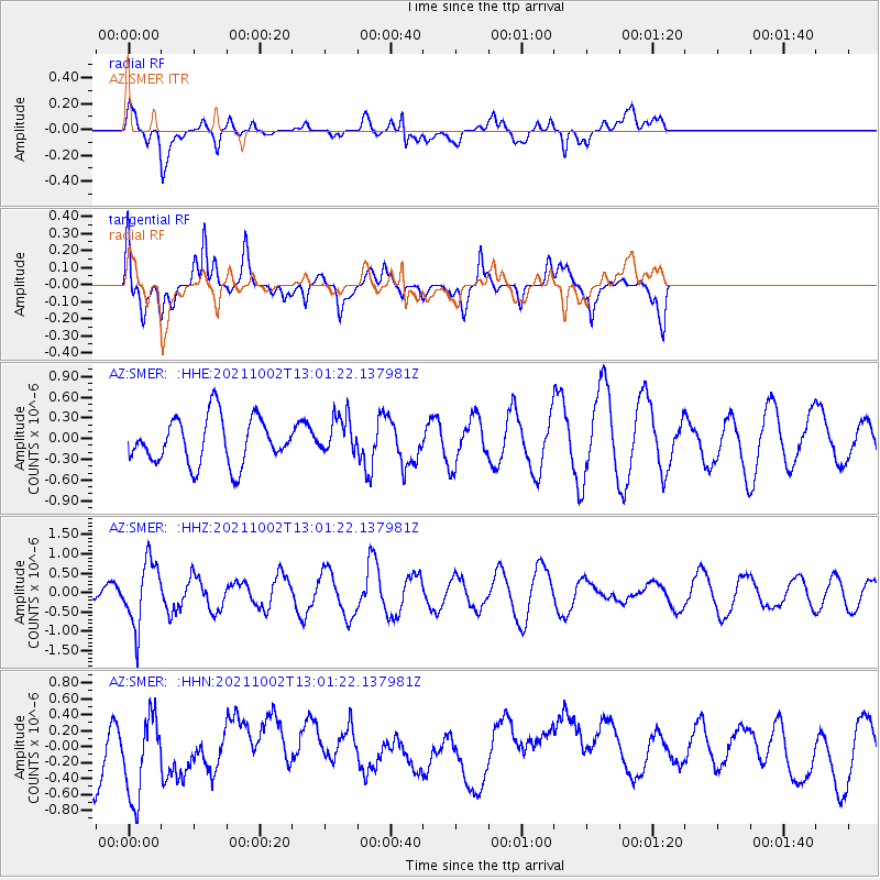
SMER AZ.SMER - Earthquake Result Viewer
*The percent match for this event was below the threshold and hence no stack was calculated.
| Earthquake location: |
Peru-Brazil Border Region |
| Earthquake latitude/longitude: |
-9.6/-71.2 |
| Earthquake time(UTC): |
2021/10/02 (275) 12:52:34 GMT |
| Earthquake Depth: |
589 km |
| Earthquake Magnitude: |
5.9 mww |
| Earthquake Catalog/Contributor: |
NEIC PDE/us |
|
| Network: |
AZ ANZA Regional Network |
| Station: |
SMER AZ.SMER |
| Lat/Lon: |
33.46 N/117.17 W |
| Elevation: |
355 m |
|
| Distance: |
61.2 deg |
| Az: |
316.673 deg |
| Baz: |
125.961 deg |
| Ray Param: |
$rayparam |
*The percent match for this event was below the threshold and hence was not used in the summary stack. |
|
| Radial Match: |
54.788315 % |
| Radial Bump: |
400 |
| Transverse Match: |
63.80568 % |
| Transverse Bump: |
400 |
| SOD ConfigId: |
25131211 |
| Insert Time: |
2021-10-16 12:56:00.863 +0000 |
| GWidth: |
2.5 |
| Max Bumps: |
400 |
| Tol: |
0.001 |
|
Signal To Noise
| Channel | StoN | STA | LTA |
| AZ:SMER: :HHZ:20211002T13:01:22.137981Z | 4.387106 | 8.333997E-7 | 1.8996573E-7 |
| AZ:SMER: :HHN:20211002T13:01:22.137981Z | 1.4871342 | 5.747076E-7 | 3.8645308E-7 |
| AZ:SMER: :HHE:20211002T13:01:22.137981Z | 0.829268 | 2.7719148E-7 | 3.3426042E-7 |
| Arrivals |
| Ps | |
| PpPs | |
| PsPs/PpSs | |


