You are here: Home > Network List > IU - Global Seismograph Network (GSN - IRIS/USGS) Stations List
> Station JOHN Johnston Island, USA > Earthquake Result Viewer
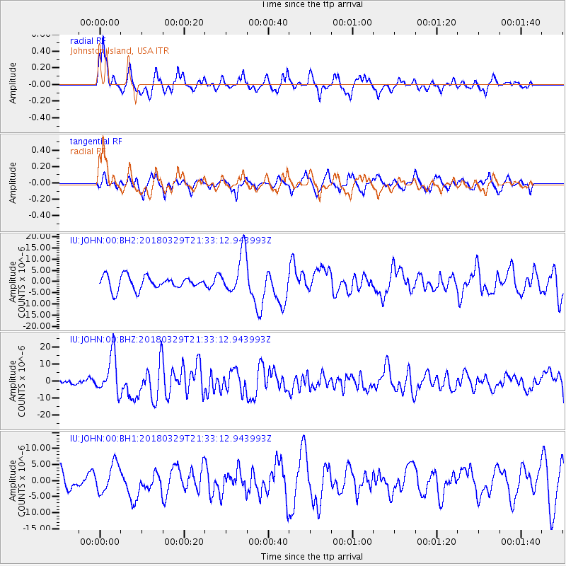
JOHN Johnston Island, USA - Earthquake Result Viewer
*The percent match for this event was below the threshold and hence no stack was calculated.
| Earthquake location: |
New Britain Region, P.N.G. |
| Earthquake latitude/longitude: |
-5.5/151.4 |
| Earthquake time(UTC): |
2018/03/29 (088) 21:25:32 GMT |
| Earthquake Depth: |
10 km |
| Earthquake Magnitude: |
6.9 mww |
| Earthquake Catalog/Contributor: |
NEIC PDE/us |
|
| Network: |
IU Global Seismograph Network (GSN - IRIS/USGS) |
| Station: |
JOHN Johnston Island, USA |
| Lat/Lon: |
16.73 N/169.53 W |
| Elevation: |
2.0 m |
|
| Distance: |
44.4 deg |
| Az: |
59.498 deg |
| Baz: |
243.53 deg |
| Ray Param: |
$rayparam |
*The percent match for this event was below the threshold and hence was not used in the summary stack. |
|
| Radial Match: |
72.40455 % |
| Radial Bump: |
330 |
| Transverse Match: |
68.92596 % |
| Transverse Bump: |
400 |
| SOD ConfigId: |
2615551 |
| Insert Time: |
2018-04-12 21:27:43.809 +0000 |
| GWidth: |
2.5 |
| Max Bumps: |
400 |
| Tol: |
0.001 |
|
Signal To Noise
| Channel | StoN | STA | LTA |
| IU:JOHN:00:BHZ:20180329T21:33:12.943993Z | 4.225401 | 1.1863475E-5 | 2.8076568E-6 |
| IU:JOHN:00:BH1:20180329T21:33:12.943993Z | 1.9941978 | 4.569462E-6 | 2.2913785E-6 |
| IU:JOHN:00:BH2:20180329T21:33:12.943993Z | 3.2467165 | 9.684981E-6 | 2.9830078E-6 |
| Arrivals |
| Ps | |
| PpPs | |
| PsPs/PpSs | |


