You are here: Home > Network List > CN - Canadian National Seismograph Network Stations List
> Station ATKO Atikokan Iron Mine, ON, CA > Earthquake Result Viewer
ATKO Atikokan Iron Mine, ON, CA - Earthquake Result Viewer
| Earthquake location: |
Peru-Brazil Border Region |
| Earthquake latitude/longitude: |
-9.6/-71.2 |
| Earthquake time(UTC): |
2021/10/02 (275) 12:52:34 GMT |
| Earthquake Depth: |
589 km |
| Earthquake Magnitude: |
5.9 mww |
| Earthquake Catalog/Contributor: |
NEIC PDE/us |
|
| Network: |
CN Canadian National Seismograph Network |
| Station: |
ATKO Atikokan Iron Mine, ON, CA |
| Lat/Lon: |
48.82 N/91.60 W |
| Elevation: |
383 m |
|
| Distance: |
60.9 deg |
| Az: |
344.7 deg |
| Baz: |
156.811 deg |
| Ray Param: |
0.058909357 |
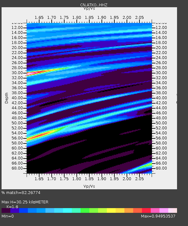
| Estimated Moho Depth: |
30.25 km |
| Estimated Crust Vp/Vs: |
1.60 |
| Assumed Crust Vp: |
6.467 km/s |
| Estimated Crust Vs: |
4.042 km/s |
| Estimated Crust Poisson's Ratio: |
0.18 |
|
| Radial Match: |
82.26774 % |
| Radial Bump: |
400 |
| Transverse Match: |
76.9427 % |
| Transverse Bump: |
359 |
| SOD ConfigId: |
25131211 |
| Insert Time: |
2021-10-16 13:00:28.986 +0000 |
| GWidth: |
2.5 |
| Max Bumps: |
400 |
| Tol: |
0.001 |
|

Signal To Noise
| Channel | StoN | STA | LTA |
| CN:ATKO: :HHZ:20211002T13:01:20.199993Z | 2.7896082 | 1.6992188E-6 | 6.091246E-7 |
| CN:ATKO: :HHN:20211002T13:01:20.199993Z | 2.5957315 | 9.22127E-7 | 3.5524744E-7 |
| CN:ATKO: :HHE:20211002T13:01:20.199993Z | 1.3091024 | 5.005796E-7 | 3.823838E-7 |
| Arrivals |
| Ps | 2.9 SECOND |
| PpPs | 12 SECOND |
| PsPs/PpSs | 15 SECOND |


