You are here: Home > Network List > G - GEOSCOPE Stations List
> Station TAM Tamanrasset, Algeria > Earthquake Result Viewer
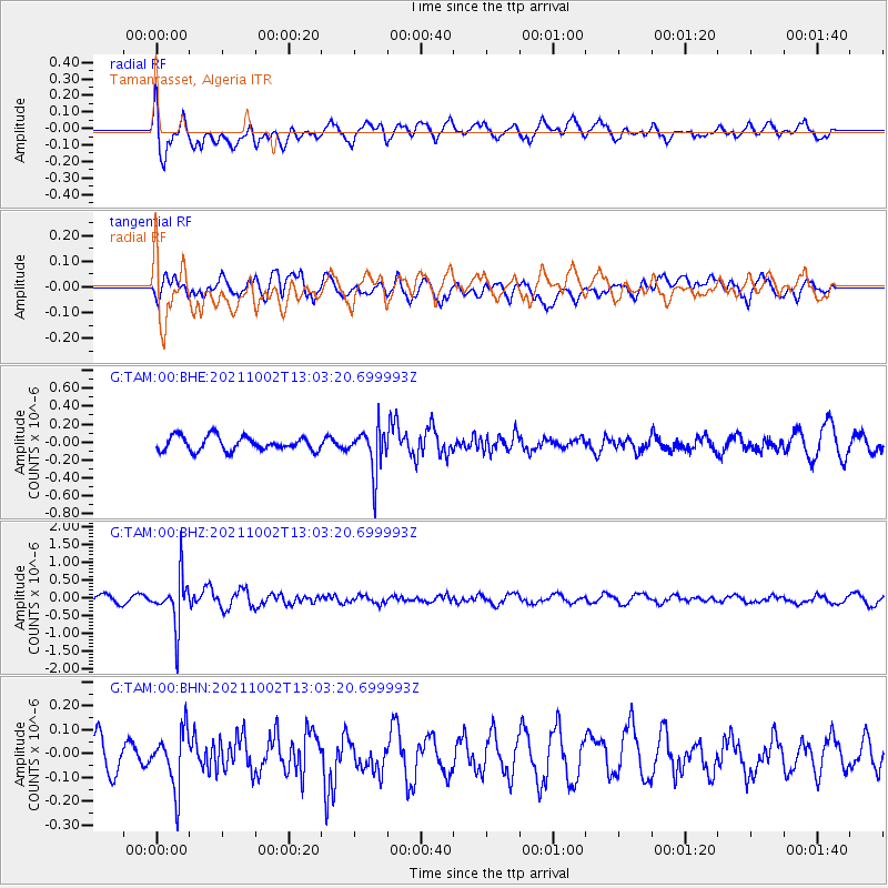
TAM Tamanrasset, Algeria - Earthquake Result Viewer
*The percent match for this event was below the threshold and hence no stack was calculated.
| Earthquake location: |
Peru-Brazil Border Region |
| Earthquake latitude/longitude: |
-9.6/-71.2 |
| Earthquake time(UTC): |
2021/10/02 (275) 12:52:34 GMT |
| Earthquake Depth: |
589 km |
| Earthquake Magnitude: |
5.9 mww |
| Earthquake Catalog/Contributor: |
NEIC PDE/us |
|
| Network: |
G GEOSCOPE |
| Station: |
TAM Tamanrasset, Algeria |
| Lat/Lon: |
22.79 N/5.53 E |
| Elevation: |
1377 m |
|
| Distance: |
81.6 deg |
| Az: |
65.2 deg |
| Baz: |
255.945 deg |
| Ray Param: |
$rayparam |
*The percent match for this event was below the threshold and hence was not used in the summary stack. |
|
| Radial Match: |
60.62932 % |
| Radial Bump: |
400 |
| Transverse Match: |
38.55281 % |
| Transverse Bump: |
400 |
| SOD ConfigId: |
25131211 |
| Insert Time: |
2021-10-16 13:03:13.183 +0000 |
| GWidth: |
2.5 |
| Max Bumps: |
400 |
| Tol: |
0.001 |
|
Signal To Noise
| Channel | StoN | STA | LTA |
| G:TAM:00:BHZ:20211002T13:03:20.699993Z | 5.544108 | 6.815291E-7 | 1.2292855E-7 |
| G:TAM:00:BHN:20211002T13:03:20.699993Z | 1.3866544 | 1.1974294E-7 | 8.635384E-8 |
| G:TAM:00:BHE:20211002T13:03:20.699993Z | 3.059871 | 2.3797928E-7 | 7.777429E-8 |
| Arrivals |
| Ps | |
| PpPs | |
| PsPs/PpSs | |


