You are here: Home > Network List > N4 - Central and EAstern US Network Stations List
> Station N41A Harden Midland Farm, Stronghurst, IL, USA > Earthquake Result Viewer
N41A Harden Midland Farm, Stronghurst, IL, USA - Earthquake Result Viewer
| Earthquake location: |
Peru-Brazil Border Region |
| Earthquake latitude/longitude: |
-9.6/-71.2 |
| Earthquake time(UTC): |
2021/10/02 (275) 12:52:34 GMT |
| Earthquake Depth: |
589 km |
| Earthquake Magnitude: |
5.9 mww |
| Earthquake Catalog/Contributor: |
NEIC PDE/us |
|
| Network: |
N4 Central and EAstern US Network |
| Station: |
N41A Harden Midland Farm, Stronghurst, IL, USA |
| Lat/Lon: |
40.71 N/90.86 W |
| Elevation: |
226 m |
|
| Distance: |
53.3 deg |
| Az: |
341.375 deg |
| Baz: |
155.524 deg |
| Ray Param: |
0.063607804 |
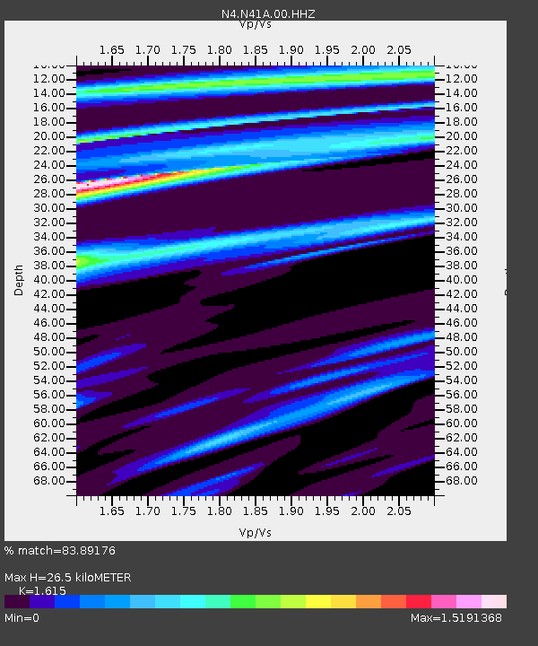
| Estimated Moho Depth: |
26.5 km |
| Estimated Crust Vp/Vs: |
1.62 |
| Assumed Crust Vp: |
6.498 km/s |
| Estimated Crust Vs: |
4.023 km/s |
| Estimated Crust Poisson's Ratio: |
0.19 |
|
| Radial Match: |
83.89176 % |
| Radial Bump: |
400 |
| Transverse Match: |
34.487675 % |
| Transverse Bump: |
400 |
| SOD ConfigId: |
25131211 |
| Insert Time: |
2021-10-16 13:07:25.296 +0000 |
| GWidth: |
2.5 |
| Max Bumps: |
400 |
| Tol: |
0.001 |
|

Signal To Noise
| Channel | StoN | STA | LTA |
| N4:N41A:00:HHZ:20211002T13:00:28.319988Z | 5.99404 | 2.735876E-6 | 4.5643276E-7 |
| N4:N41A:00:HH1:20211002T13:00:28.319988Z | 3.7975478 | 1.3458208E-6 | 3.5439206E-7 |
| N4:N41A:00:HH2:20211002T13:00:28.319988Z | 4.351741 | 7.62763E-7 | 1.7527766E-7 |
| Arrivals |
| Ps | 2.7 SECOND |
| PpPs | 10 SECOND |
| PsPs/PpSs | 13 SECOND |


