You are here: Home > Network List > AK - Alaska Regional Network Stations List
> Station PNL Peninsula > Earthquake Result Viewer
PNL Peninsula - Earthquake Result Viewer
| Earthquake location: |
Santa Cruz Islands |
| Earthquake latitude/longitude: |
-11.6/165.8 |
| Earthquake time(UTC): |
2007/09/02 (245) 01:05:18 GMT |
| Earthquake Depth: |
35 km |
| Earthquake Magnitude: |
5.9 MB, 7.3 MS, 7.2 MW, 6.9 ME |
| Earthquake Catalog/Contributor: |
WHDF/NEIC |
|
| Network: |
AK Alaska Regional Network |
| Station: |
PNL Peninsula |
| Lat/Lon: |
59.67 N/139.40 W |
| Elevation: |
596 m |
|
| Distance: |
83.4 deg |
| Az: |
24.687 deg |
| Baz: |
233.735 deg |
| Ray Param: |
0.046132606 |
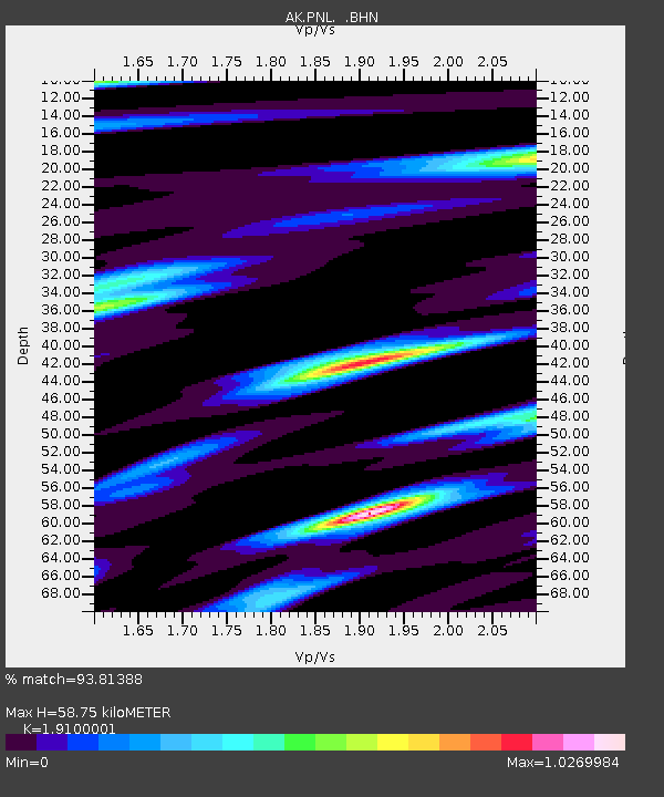
| Estimated Moho Depth: |
58.75 km |
| Estimated Crust Vp/Vs: |
1.91 |
| Assumed Crust Vp: |
6.183 km/s |
| Estimated Crust Vs: |
3.237 km/s |
| Estimated Crust Poisson's Ratio: |
0.31 |
|
| Radial Match: |
93.81388 % |
| Radial Bump: |
400 |
| Transverse Match: |
88.88414 % |
| Transverse Bump: |
400 |
| SOD ConfigId: |
2564 |
| Insert Time: |
2010-03-09 13:16:50.242 +0000 |
| GWidth: |
2.5 |
| Max Bumps: |
400 |
| Tol: |
0.001 |
|

Signal To Noise
| Channel | StoN | STA | LTA |
| AK:PNL: :BHN:20070902T01:17:10.939001Z | 7.839805 | 9.320542E-7 | 1.1888742E-7 |
| AK:PNL: :BHE:20070902T01:17:10.939001Z | 4.792842 | 6.117775E-7 | 1.27644E-7 |
| AK:PNL: :BHZ:20070902T01:17:10.939001Z | 20.68096 | 2.713941E-6 | 1.3122897E-7 |
| Arrivals |
| Ps | 8.8 SECOND |
| PpPs | 27 SECOND |
| PsPs/PpSs | 36 SECOND |


