You are here: Home > Network List > N4 - Central and EAstern US Network Stations List
> Station O52A Adamsville, OH, USA > Earthquake Result Viewer
O52A Adamsville, OH, USA - Earthquake Result Viewer
| Earthquake location: |
Peru-Brazil Border Region |
| Earthquake latitude/longitude: |
-9.6/-71.2 |
| Earthquake time(UTC): |
2021/10/02 (275) 12:52:34 GMT |
| Earthquake Depth: |
589 km |
| Earthquake Magnitude: |
5.9 mww |
| Earthquake Catalog/Contributor: |
NEIC PDE/us |
|
| Network: |
N4 Central and EAstern US Network |
| Station: |
O52A Adamsville, OH, USA |
| Lat/Lon: |
40.12 N/81.84 W |
| Elevation: |
331 m |
|
| Distance: |
50.4 deg |
| Az: |
349.404 deg |
| Baz: |
166.322 deg |
| Ray Param: |
0.06533298 |
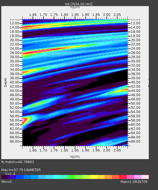
| Estimated Moho Depth: |
57.75 km |
| Estimated Crust Vp/Vs: |
1.60 |
| Assumed Crust Vp: |
6.483 km/s |
| Estimated Crust Vs: |
4.052 km/s |
| Estimated Crust Poisson's Ratio: |
0.18 |
|
| Radial Match: |
80.79983 % |
| Radial Bump: |
400 |
| Transverse Match: |
80.27171 % |
| Transverse Bump: |
325 |
| SOD ConfigId: |
25131211 |
| Insert Time: |
2021-10-16 13:07:39.338 +0000 |
| GWidth: |
2.5 |
| Max Bumps: |
400 |
| Tol: |
0.001 |
|

Signal To Noise
| Channel | StoN | STA | LTA |
| N4:O52A:00:HHZ:20211002T13:00:08.220012Z | 7.1074066 | 1.8383628E-6 | 2.586545E-7 |
| N4:O52A:00:HH1:20211002T13:00:08.220012Z | 4.7101383 | 8.9355325E-7 | 1.897085E-7 |
| N4:O52A:00:HH2:20211002T13:00:08.220012Z | 1.6510541 | 6.4745893E-7 | 3.9214882E-7 |
| Arrivals |
| Ps | 5.7 SECOND |
| PpPs | 22 SECOND |
| PsPs/PpSs | 27 SECOND |


