You are here: Home > Network List > O2 - Oklahoma Consolidated Temporary Seismic Networks Stations List
> Station PW09 Ralston, Oklahoma > Earthquake Result Viewer
PW09 Ralston, Oklahoma - Earthquake Result Viewer
| Earthquake location: |
Peru-Brazil Border Region |
| Earthquake latitude/longitude: |
-9.6/-71.2 |
| Earthquake time(UTC): |
2021/10/02 (275) 12:52:34 GMT |
| Earthquake Depth: |
589 km |
| Earthquake Magnitude: |
5.9 mww |
| Earthquake Catalog/Contributor: |
NEIC PDE/us |
|
| Network: |
O2 Oklahoma Consolidated Temporary Seismic Networks |
| Station: |
PW09 Ralston, Oklahoma |
| Lat/Lon: |
36.45 N/96.82 W |
| Elevation: |
291 m |
|
| Distance: |
51.8 deg |
| Az: |
333.636 deg |
| Baz: |
147.102 deg |
| Ray Param: |
0.06452371 |
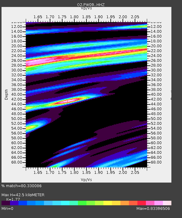
| Estimated Moho Depth: |
42.5 km |
| Estimated Crust Vp/Vs: |
1.77 |
| Assumed Crust Vp: |
6.483 km/s |
| Estimated Crust Vs: |
3.662 km/s |
| Estimated Crust Poisson's Ratio: |
0.27 |
|
| Radial Match: |
80.330086 % |
| Radial Bump: |
370 |
| Transverse Match: |
54.40363 % |
| Transverse Bump: |
400 |
| SOD ConfigId: |
25131211 |
| Insert Time: |
2021-10-16 13:11:20.444 +0000 |
| GWidth: |
2.5 |
| Max Bumps: |
400 |
| Tol: |
0.001 |
|

Signal To Noise
| Channel | StoN | STA | LTA |
| O2:PW09: :HHZ:20211002T13:00:17.764995Z | 9.697585 | 2.3153202E-6 | 2.3875225E-7 |
| O2:PW09: :HHN:20211002T13:00:17.764995Z | 5.3997355 | 9.287321E-7 | 1.7199585E-7 |
| O2:PW09: :HHE:20211002T13:00:17.764995Z | 3.624343 | 6.532622E-7 | 1.8024294E-7 |
| Arrivals |
| Ps | 5.3 SECOND |
| PpPs | 17 SECOND |
| PsPs/PpSs | 23 SECOND |


