You are here: Home > Network List > TX - Texas Seismological Network Stations List
> Station WTFS Witchita Falls > Earthquake Result Viewer
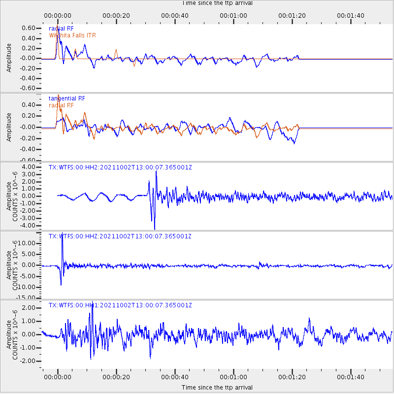
WTFS Witchita Falls - Earthquake Result Viewer
*The percent match for this event was below the threshold and hence no stack was calculated.
| Earthquake location: |
Peru-Brazil Border Region |
| Earthquake latitude/longitude: |
-9.6/-71.2 |
| Earthquake time(UTC): |
2021/10/02 (275) 12:52:34 GMT |
| Earthquake Depth: |
589 km |
| Earthquake Magnitude: |
5.9 mww |
| Earthquake Catalog/Contributor: |
NEIC PDE/us |
|
| Network: |
TX Texas Seismological Network |
| Station: |
WTFS Witchita Falls |
| Lat/Lon: |
33.77 N/98.46 W |
| Elevation: |
277 m |
|
| Distance: |
50.3 deg |
| Az: |
330.258 deg |
| Baz: |
144.034 deg |
| Ray Param: |
$rayparam |
*The percent match for this event was below the threshold and hence was not used in the summary stack. |
|
| Radial Match: |
76.359055 % |
| Radial Bump: |
400 |
| Transverse Match: |
60.565933 % |
| Transverse Bump: |
400 |
| SOD ConfigId: |
25131211 |
| Insert Time: |
2021-10-16 13:16:10.552 +0000 |
| GWidth: |
2.5 |
| Max Bumps: |
400 |
| Tol: |
0.001 |
|
Signal To Noise
| Channel | StoN | STA | LTA |
| TX:WTFS:00:HHZ:20211002T13:00:07.365001Z | 19.13312 | 3.7604589E-6 | 1.9654185E-7 |
| TX:WTFS:00:HH1:20211002T13:00:07.365001Z | 2.297269 | 4.7764934E-7 | 2.079205E-7 |
| TX:WTFS:00:HH2:20211002T13:00:07.365001Z | 4.869459 | 1.5506321E-6 | 3.184403E-7 |
| Arrivals |
| Ps | |
| PpPs | |
| PsPs/PpSs | |


