You are here: Home > Network List > US - United States National Seismic Network Stations List
> Station LAO LASA Array, Montana, USA > Earthquake Result Viewer
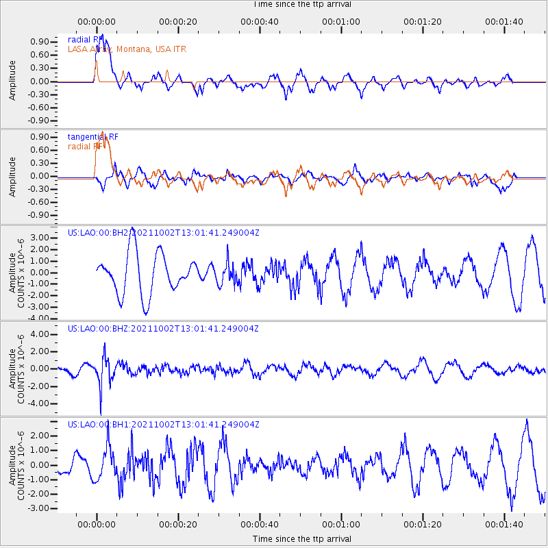
LAO LASA Array, Montana, USA - Earthquake Result Viewer
*The percent match for this event was below the threshold and hence no stack was calculated.
| Earthquake location: |
Peru-Brazil Border Region |
| Earthquake latitude/longitude: |
-9.6/-71.2 |
| Earthquake time(UTC): |
2021/10/02 (275) 12:52:34 GMT |
| Earthquake Depth: |
589 km |
| Earthquake Magnitude: |
5.9 mww |
| Earthquake Catalog/Contributor: |
NEIC PDE/us |
|
| Network: |
US United States National Seismic Network |
| Station: |
LAO LASA Array, Montana, USA |
| Lat/Lon: |
46.69 N/106.22 W |
| Elevation: |
902 m |
|
| Distance: |
64.2 deg |
| Az: |
333.954 deg |
| Baz: |
141.021 deg |
| Ray Param: |
$rayparam |
*The percent match for this event was below the threshold and hence was not used in the summary stack. |
|
| Radial Match: |
65.396255 % |
| Radial Bump: |
390 |
| Transverse Match: |
47.53663 % |
| Transverse Bump: |
359 |
| SOD ConfigId: |
25131211 |
| Insert Time: |
2021-10-16 13:17:43.797 +0000 |
| GWidth: |
2.5 |
| Max Bumps: |
400 |
| Tol: |
0.001 |
|
Signal To Noise
| Channel | StoN | STA | LTA |
| US:LAO:00:BHZ:20211002T13:01:41.249004Z | 2.30208 | 1.5987523E-6 | 6.944816E-7 |
| US:LAO:00:BH1:20211002T13:01:41.249004Z | 1.1384118 | 1.1542465E-6 | 1.0139096E-6 |
| US:LAO:00:BH2:20211002T13:01:41.249004Z | 0.5242613 | 9.1754714E-7 | 1.7501714E-6 |
| Arrivals |
| Ps | |
| PpPs | |
| PsPs/PpSs | |


