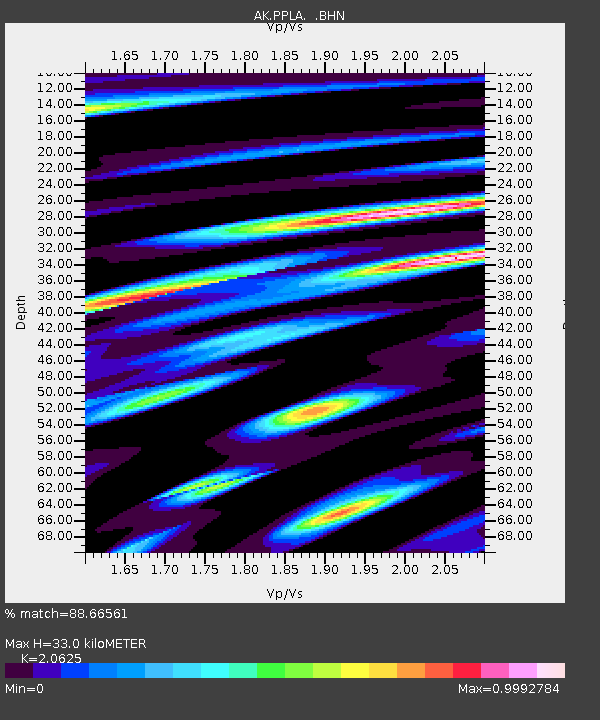
PPLA Purkeypile - Earthquake Result Viewer

Earthquake location: Off East Coast Of Honshu, Japan
Earthquake latitude/longitude: 38.1/144.9
Earthquake time(UTC): 2005/11/14 (318) 21:38:51 GMT
Earthquake Depth: 11 km
Earthquake Magnitude: 6.7 MB, 6.8 MS, 7.0 MW, 6.9 MW
Earthquake Catalog/Contributor: WHDF/NEIC
Network: AK Alaska Regional Network
Station: PPLA Purkeypile
Lat/Lon: 62.90 N/152.19 W
Elevation: 1519 m
Distance: 44.7 deg
Az: 35.434 deg
Baz: 266.921 deg
Ray Param: 0.071753405
Estimated Moho Depth: 33.0 km
Estimated Crust Vp/Vs: 2.06
Assumed Crust Vp: 6.566 km/s
Estimated Crust Vs: 3.184 km/s
Estimated Crust Poisson's Ratio: 0.35
Radial Match: 88.66561 %
Radial Bump: 400
Transverse Match: 85.0952 %
Transverse Bump: 400
SOD ConfigId: 2448
Insert Time: 2010-03-09 13:18:30.400 +0000
GWidth: 2.5
Max Bumps: 400
Tol: 0.001

Signal To Noise

ChannelStoNSTALTA
AK:PPLA: :BHN:20051114T21:46:33.426989Z4.45757771.335983E-62.9971054E-7
AK:PPLA: :BHE:20051114T21:46:33.426989Z4.1709691.7776322E-64.2619166E-7
AK:PPLA: :BHZ:20051114T21:46:33.426989Z18.4394155.023979E-62.724587E-7
Arrivals
Ps5.7 SECOND
PpPs15 SECOND
PsPs/PpSs20 SECOND