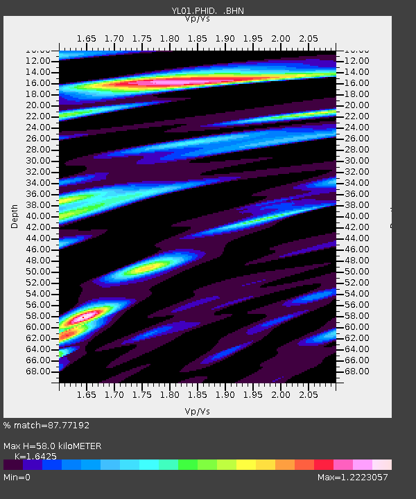
PHID YL.PHID - Earthquake Result Viewer
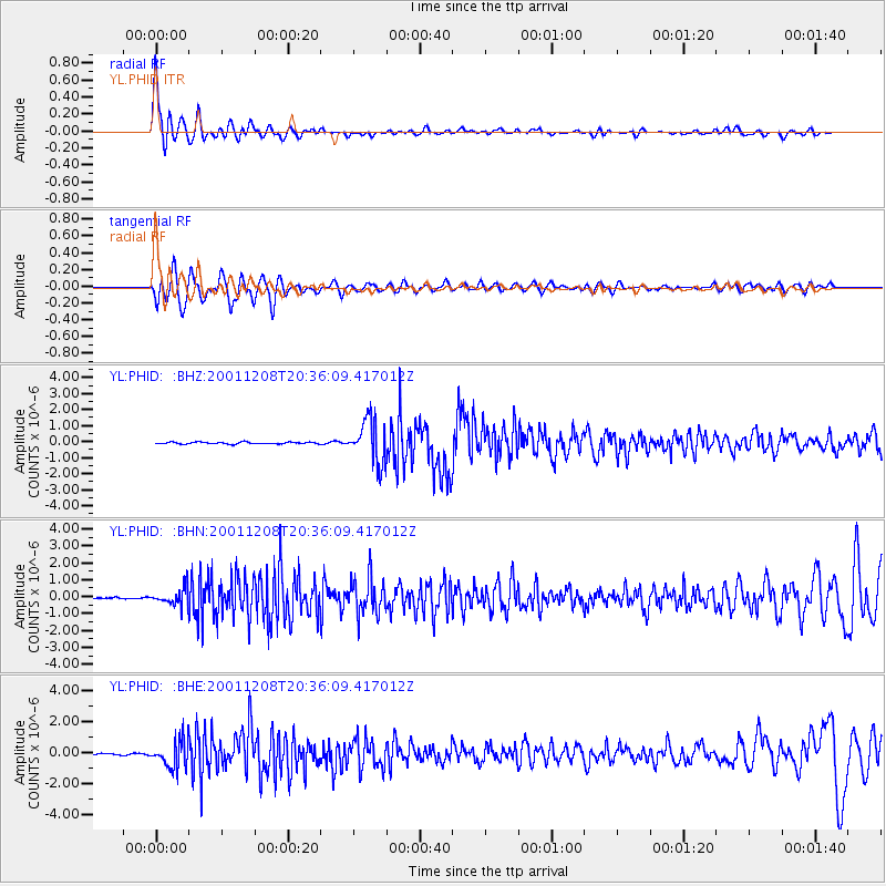
Earthquake location: Ryukyu Islands, Japan
Earthquake latitude/longitude: 28.3/129.6
Earthquake time(UTC): 2001/12/08 (342) 20:29:34 GMT
Earthquake Depth: 33 km
Earthquake Magnitude: 5.7 MB, 5.7 MS, 6.2 MW, 6.1 MW
Earthquake Catalog/Contributor: WHDF/NEIC
Network: YL Himalayan Nepal Tibet Experiment
Station: PHID YL.PHID
Lat/Lon: 27.15 N/87.76 E
Elevation: 1176 m
Distance: 36.9 deg
Az: 278.398 deg
Baz: 78.365 deg
Ray Param: 0.07636613
Estimated Moho Depth: 58.0 km
Estimated Crust Vp/Vs: 1.64
Assumed Crust Vp: 6.236 km/s
Estimated Crust Vs: 3.797 km/s
Estimated Crust Poisson's Ratio: 0.21
Radial Match: 87.77192 %
Radial Bump: 400
Transverse Match: 81.975685 %
Transverse Bump: 400
SOD ConfigId: 16820
Insert Time: 2010-02-26 16:03:11.241 +0000
GWidth: 2.5
Max Bumps: 400
Tol: 0.001

Signal To Noise

ChannelStoNSTALTA
YL:PHID: :BHN:20011208T20:36:09.417012Z13.0432694.9409437E-73.7881176E-8
YL:PHID: :BHE:20011208T20:36:09.417012Z23.9894248.9193503E-73.7180342E-8
YL:PHID: :BHZ:20011208T20:36:09.417012Z22.9549541.3344784E-65.813466E-8
Arrivals
Ps6.4 SECOND
PpPs23 SECOND
PsPs/PpSs29 SECOND