You are here: Home > Network List > AV - Alaska Volcano Observatory Stations List
> Station SPCR Ckakachatna River, Mount Spurr, Alaska > Earthquake Result Viewer
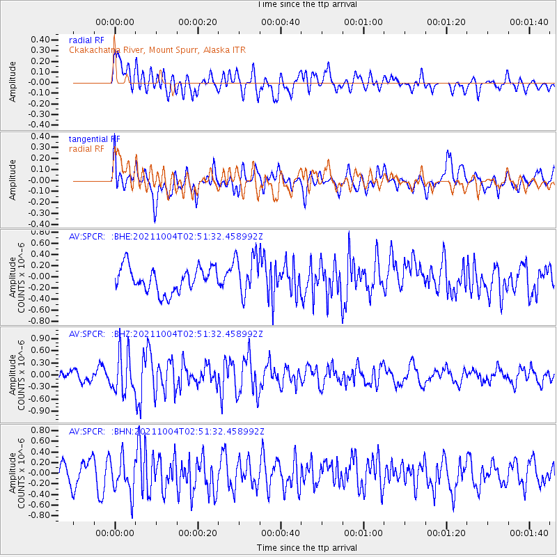
SPCR Ckakachatna River, Mount Spurr, Alaska - Earthquake Result Viewer
*The percent match for this event was below the threshold and hence no stack was calculated.
| Earthquake location: |
Western Iran |
| Earthquake latitude/longitude: |
32.3/49.8 |
| Earthquake time(UTC): |
2021/10/04 (277) 02:39:27 GMT |
| Earthquake Depth: |
10 km |
| Earthquake Magnitude: |
5.6 mww |
| Earthquake Catalog/Contributor: |
NEIC PDE/us |
|
| Network: |
AV Alaska Volcano Observatory |
| Station: |
SPCR Ckakachatna River, Mount Spurr, Alaska |
| Lat/Lon: |
61.20 N/152.21 W |
| Elevation: |
984 m |
|
| Distance: |
85.2 deg |
| Az: |
10.471 deg |
| Baz: |
341.462 deg |
| Ray Param: |
$rayparam |
*The percent match for this event was below the threshold and hence was not used in the summary stack. |
|
| Radial Match: |
44.345753 % |
| Radial Bump: |
400 |
| Transverse Match: |
52.66077 % |
| Transverse Bump: |
400 |
| SOD ConfigId: |
25131211 |
| Insert Time: |
2021-10-18 02:46:08.893 +0000 |
| GWidth: |
2.5 |
| Max Bumps: |
400 |
| Tol: |
0.001 |
|
Signal To Noise
| Channel | StoN | STA | LTA |
| AV:SPCR: :BHZ:20211004T02:51:32.458992Z | 3.4969647 | 5.042997E-7 | 1.4421069E-7 |
| AV:SPCR: :BHN:20211004T02:51:32.458992Z | 1.4864247 | 3.299966E-7 | 2.2200695E-7 |
| AV:SPCR: :BHE:20211004T02:51:32.458992Z | 1.652699 | 3.6349851E-7 | 2.1994236E-7 |
| Arrivals |
| Ps | |
| PpPs | |
| PsPs/PpSs | |


