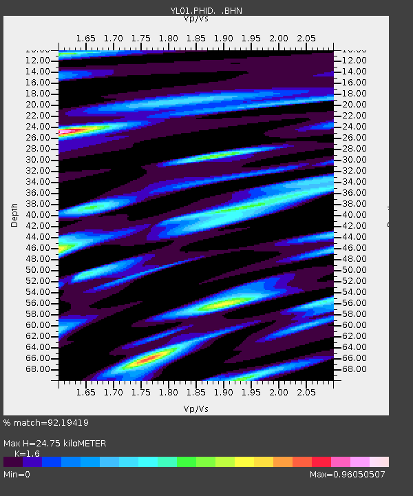
PHID YL.PHID - Earthquake Result Viewer
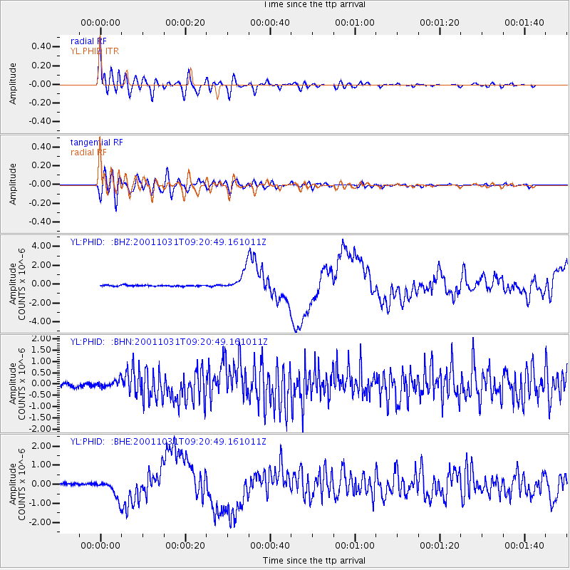
Earthquake location: New Britain Region, P.N.G.
Earthquake latitude/longitude: -5.9/150.2
Earthquake time(UTC): 2001/10/31 (304) 09:10:20 GMT
Earthquake Depth: 33 km
Earthquake Magnitude: 5.9 MB, 6.9 MS, 6.9 MW, 6.9 MW
Earthquake Catalog/Contributor: WHDF/NEIC
Network: YL Himalayan Nepal Tibet Experiment
Station: PHID YL.PHID
Lat/Lon: 27.15 N/87.76 E
Elevation: 1176 m
Distance: 68.7 deg
Az: 302.007 deg
Baz: 108.797 deg
Ray Param: 0.05610314
Estimated Moho Depth: 24.75 km
Estimated Crust Vp/Vs: 1.60
Assumed Crust Vp: 6.236 km/s
Estimated Crust Vs: 3.897 km/s
Estimated Crust Poisson's Ratio: 0.18
Radial Match: 92.19419 %
Radial Bump: 400
Transverse Match: 75.34559 %
Transverse Bump: 400
SOD ConfigId: 16820
Insert Time: 2010-02-26 16:03:15.171 +0000
GWidth: 2.5
Max Bumps: 400
Tol: 0.001

Signal To Noise

ChannelStoNSTALTA
YL:PHID: :BHN:20011031T09:20:49.161011Z2.31824041.6943774E-77.308894E-8
YL:PHID: :BHE:20011031T09:20:49.161011Z8.2902955.0754215E-76.122124E-8
YL:PHID: :BHZ:20011031T09:20:49.161011Z20.5348741.1755671E-65.724735E-8
Arrivals
Ps2.5 SECOND
PpPs9.9 SECOND
PsPs/PpSs12 SECOND